Zhaozhen geodata
Zhaozhen (Sichuan) is a seat of a third-order administrative division; located in China in Asia/Shanghai (GMT+8) time zone. In our database, there are 1268 cities with bigger population. Compared to other cities in China, 53.5% of cities are located further ↓South; 89.8% of cities are located further →East and 71.9% of cities have lower elevation than Zhaozhen. Note1


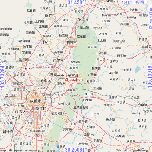
Zhaozhen GPS coordinates[2]
30° 51' 22.68" North, 104° 26' 9.816" East
| Map corner | latitude | longitude |
|---|---|---|
| Upper-left | 31.458°, | 103.73294° |
| Center: | 30.8563°, | 104.43606° |
| Lower-right: | 30.25081°, | 105.13919° |
| Map W x H: | 134.2×134.2 km | = 83.4×83.4mi |
| max Lat: | 53.31946° ⇑46.5% North |
| Zhaozhen: | 30.8563° |
| min Lat: | ⇓53.5% South 18.22056° |
| min Long | Zhaozhen | max Long |
| 75.07348° | 104.43606° | 134.28917° |
| W 10.2%⇐ | ⇒89.8% E |
Elevation
Elevation of Zhaozhen is 450 m = 1476 ft, and this is 34.8 m = 114 ft below average elevation for this country.
| Max E: |
5622 m = 18445 ft | 28.1% |
| Avg. | 484.8 m = 1591 ft | |
| Zhaozhen | 450 m = 1476 ft | |
Min E: |
-3 m = -10 ft | 71.9% |
See also: China elevation on elevation.city.
Geographical zone
Zhaozhen is located in North temperate zone (between Tropic of Cancer and the Arctic Circle). Distance of this Northern Tropic circle is 825 km =512.6 mi to South.| Distance of | km | miles | from Zhaozhen |
|---|---|---|---|
| North Pole | 6576.2 | 4086.3 | to North |
| Arctic Circle | 3970.3 | 2467 | to North |
| Tropic Cancer | 825 | 512.6 | to South |
| Equator | 3430.9 | 2131.9 | to South |


Nearby cities:
15 places around Zhaozhen: (largest is in red/bold)
• Chengdu
41.1 km =25.5 mi,  239°
239°
• Deyang
30.9 km =19.2 mi,  350°
350°
• Dongsheng
58.4 km =36.3 mi, 237°
• Fangting
39.6 km =24.6 mi,  319°
319°
• Jiancheng
52.9 km =32.9 mi,  168°
168°
• Jiannan
58.8 km =36.5 mi,  337°
337°
• Kaijiang
30.5 km =19 mi,  48°
48°
• Liucheng
59.7 km =37.1 mi,  253°
253°
• Longquan
36.5 km =22.7 mi,  205°
205°
• Luocheng
20.2 km =12.6 mi,  312°
312°
• Luojiang
50.3 km =31.3 mi,  7°
7°
• Pitong
53.1 km =33 mi,  264°
264°
• Tianpeng
49.5 km =30.8 mi,  287°
287°
• Xindu
26.9 km =16.7 mi, 261°
• Xipu
45.9 km =28.5 mi, 256°
Sources, notices
• [Note1] Compared only with cities in China existing in our database
• [Src1] Map data: © OpenStreetMap contributors (CC-BY-SA)
• [Src2] Other city data from geonames.org with taken over terms of usage.
• [Src3] Geographical zone / Annual Mean Temperature by Robert A. Rohde @ Wikipedia
