Longquan geodata
Longquan (Sichuan) is a seat of a third-order administrative division; located in China in Asia/Shanghai (GMT+8) time zone. In our database, there are 1268 cities with bigger population. Compared to other cities in China, 50.8% of cities are located further ↓South; 90% of cities are located further →East and 75.1% of cities have lower elevation than Longquan. Note1


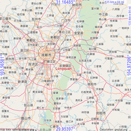
Longquan GPS coordinates[2]
30° 33' 40.68" North, 104° 16' 8.148" East
| Map corner | latitude | longitude |
|---|---|---|
| Upper-left | 31.16485°, | 103.56581° |
| Center: | 30.5613°, | 104.26893° |
| Lower-right: | 29.95397°, | 104.97206° |
| Map W x H: | 134.6×134.6 km | = 83.6×83.6mi |
| max Lat: | 53.31946° ⇑49.2% North |
| Longquan: | 30.5613° |
| min Lat: | ⇓50.8% South 18.22056° |
| min Long | Longquan | max Long |
| 75.07348° | 104.26893° | 134.28917° |
| W 10%⇐ | ⇒90% E |
Elevation
Elevation of Longquan is 523 m = 1716 ft, and this is 38.2 m = 125 ft above average elevation for this country.
| Max E: |
5622 m = 18445 ft | 24.9% |
| Longquan | 523 m 1716 ft | |
| Avg. | 484.8 m = 1591 ft | |
Min E: |
-3 m = -10 ft | 75.1% |
See also: China elevation on elevation.city.
Geographical zone
Longquan is located in North temperate zone (between Tropic of Cancer and the Arctic Circle). Distance of this Northern Tropic circle is 792.2 km =492.3 mi to South.| Distance of | km | miles | from Longquan |
|---|---|---|---|
| North Pole | 6609 | 4106.6 | to North |
| Arctic Circle | 4003.1 | 2487.4 | to North |
| Tropic Cancer | 792.2 | 492.3 | to South |
| Equator | 3398.1 | 2111.5 | to South |


Nearby cities:
15 places around Longquan: (largest is in red/bold)
• Chengdu
22.6 km =14 mi,  301°
301°
• Dongsheng
33.3 km =20.7 mi,  272°
272°
• Fangting
63.7 km =39.6 mi,  351°
351°
• Guangsheng
60.6 km =37.7 mi,  288°
288°
• Jiancheng
32.9 km =20.4 mi,  125°
125°
• Liucheng
44 km =27.3 mi, 290°
• Luocheng
46.6 km =29 mi,  1°
1°
• Pitong
46.1 km =28.6 mi,  306°
306°
• Tianpeng
56.8 km =35.3 mi,  326°
326°
• Wujin
46.8 km =29.1 mi,  249°
249°
• Xindu
30.9 km =19.2 mi,  339°
339°
• Xipu
35.9 km =22.3 mi, 307°
• Yanjiang
61 km =37.9 mi,  143°
143°
• Zhaozhen
36.5 km =22.7 mi,  25°
25°
• Zitong
58.6 km =36.4 mi, 290°
Sources, notices
• [Note1] Compared only with cities in China existing in our database
• [Src1] Map data: © OpenStreetMap contributors (CC-BY-SA)
• [Src2] Other city data from geonames.org with taken over terms of usage.
• [Src3] Geographical zone / Annual Mean Temperature by Robert A. Rohde @ Wikipedia
