Chengdu geodata
Chengdu (Sichuan) is a seat of a first-order administrative division; located in China in Asia/Shanghai (GMT+8) time zone. With population of 7,415,590 people, there are 8 cities with bigger population in this country. Compared to other cities in China, 51.8% of cities are located further ↓South; 90.2% of cities are located further →East and 73.9% of cities have lower elevation than Chengdu. Note1


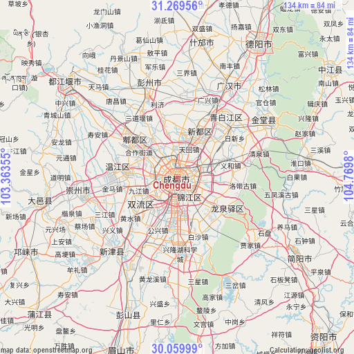
Chengdu GPS coordinates[2]
30° 40' 0.012" North, 104° 4' 0.012" East
| Map corner | latitude | longitude |
|---|---|---|
| Upper-left | 31.26956°, | 103.36355° |
| Center: | 30.66667°, | 104.06667° |
| Lower-right: | 30.05999°, | 104.7698° |
| Map W x H: | 134.5×134.5 km | = 83.6×83.6mi |
| max Lat: | 53.31946° ⇑48.2% North |
| Chengdu: | 30.66667° |
| min Lat: | ⇓51.8% South 18.22056° |
| min Long | Chengdu | max Long |
| 75.07348° | 104.06667° | 134.28917° |
| W 9.8%⇐ | ⇒90.2% E |
Elevation
Elevation of Chengdu is 499 m = 1637 ft, and this is 14.2 m = 47 ft above average elevation for this country.
| Max E: |
5622 m = 18445 ft | 26.1% |
| Chengdu | 499 m 1637 ft | |
| Avg. | 484.8 m = 1591 ft | |
Min E: |
-3 m = -10 ft | 73.9% |
See also: Chengdu elevation on elevation.city.
Geographical zone
Chengdu is located in North temperate zone (between Tropic of Cancer and the Arctic Circle). Distance of this Northern Tropic circle is 803.9 km =499.5 mi to South.| Distance of | km | miles | from Chengdu |
|---|---|---|---|
| North Pole | 6597.2 | 4099.3 | to North |
| Arctic Circle | 3991.4 | 2480.1 | to North |
| Tropic Cancer | 803.9 | 499.5 | to South |
| Equator | 3409.8 | 2118.8 | to South |


Nearby cities:
15 places around Chengdu: (largest is in red/bold)
• Deyang
59.7 km =37.1 mi,  30°
30°
• Dongsheng
17.3 km =10.7 mi,  233°
233°
• Fangting
52.1 km =32.4 mi,  10°
10°
• Guangsheng
38.8 km =24.1 mi,  281°
281°
• Jiancheng
55.5 km =34.5 mi,  123°
123°
• Liucheng
22.2 km =13.8 mi, 279°
• Longquan
22.6 km =14 mi, 121°
• Luocheng
40.4 km =25.1 mi, 30°
• Pitong
23.7 km =14.7 mi,  312°
312°
• Tianpeng
37.6 km =23.4 mi,  341°
341°
• Wujin
37.4 km =23.2 mi,  220°
220°
• Xindu
19.4 km =12.1 mi, 26°
• Xipu
13.7 km =8.5 mi,  317°
317°
• Zhaozhen
41.1 km =25.5 mi,  59°
59°
• Zitong
36.6 km =22.7 mi, 284°
Sources, notices
• [Note1] Compared only with cities in China existing in our database
• [Src1] Map data: © OpenStreetMap contributors (CC-BY-SA)
• [Src2] Other city data from geonames.org with taken over terms of usage.
• [Src3] Geographical zone / Annual Mean Temperature by Robert A. Rohde @ Wikipedia
