Jingchuan Chengguanzhen geodata
Jingchuan Chengguanzhen (Gansu) is a seat of a third-order administrative division; located in China in Asia/Shanghai (GMT+8) time zone. In our database, there are 1268 cities with bigger population. Compared to other cities in China, 75.7% of cities are located further ↓South; 82.6% of cities are located further →East and 85.8% of cities have lower elevation than Jingchuan Chengguanzhen. Note1
Current local time in Jingchuan Chengguanzhen:
04:47 PM, TuesdayDifference from your time zone: hours


Jingchuan Chengguanzhen GPS coordinates[2]
35° 19' 54.984" North, 107° 21' 39.996" East
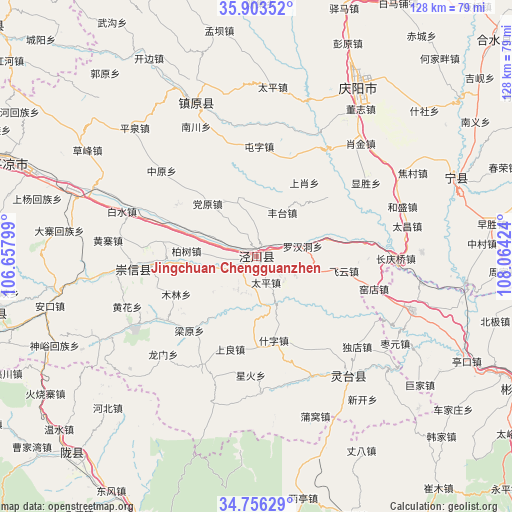
| Map corner | latitude | longitude |
|---|---|---|
| Upper-left | 35.90352°, | 106.65799° |
| Center: | 35.33194°, | 107.36111° |
| Lower-right: | 34.75629°, | 108.06424° |
| Map W x H: | 127.6×127.6 km | = 79.3×79.3mi |
| max Lat: | 53.31946° ⇑24.3% North |
| Jingchuan Chengguanzhen: | 35.33194° |
| min Lat: | ⇓75.7% South 18.22056° |
| min Long | Jingchuan Cheng | max Long |
| 75.07348° | 107.36111° | 134.28917° |
| W 17.4%⇐ | ⇒82.6% E |
Elevation
Elevation of Jingchuan Chengguanzhen is 1033 m = 3389 ft, and this is 548.2 m = 1799 ft above average elevation for this country.
| Max E: |
5622 m = 18445 ft | 14.2% |
| Jingchuan Chengguanzhen | 1033 m 3389 ft | |
| Avg. | 484.8 m = 1591 ft | |
Min E: |
-3 m = -10 ft | 85.8% |
See also: China elevation on elevation.city.
Geographical zone
Jingchuan Chengguanzhen is located in North temperate zone (between Tropic of Cancer and the Arctic Circle). Distance of this Northern Tropic circle is 1322.6 km =821.8 mi to South.| Distance of | km | miles | from Jingchuan Chengguanzhen |
|---|---|---|---|
| North Pole | 6078.5 | 3777 | to North |
| Arctic Circle | 3472.6 | 2157.8 | to North |
| Tropic Cancer | 1322.6 | 821.8 | to South |
| Equator | 3928.5 | 2441.1 | to South |


Nearby cities:
15 places around Jingchuan Chengguanzhen: (largest is in red/bold)
• Ankou
53 km =32.9 mi,  256°
256°
• Chejiazhuang
62.1 km =38.6 mi,  127°
127°
• Gaoya
48.6 km =30.2 mi,  185°
185°
• Hexi
58.4 km =36.3 mi,  137°
137°
• Jinping
30.2 km =18.8 mi,  266°
266°
• Jiufang
57.6 km =35.8 mi,  177°
177°
• Liangting
61.5 km =38.2 mi,  169°
169°
• Nanjie
51.3 km =31.9 mi,  28°
28°
• Puwo
42.4 km =26.3 mi,  159°
159°
• Shaozhai
55.3 km =34.4 mi, 133°
• Tiantang
49 km =30.4 mi, 159°
• Xinning
53.8 km =33.4 mi,  70°
70°
• Zhangba
55 km =34.2 mi,  151°
151°
• Zhaoren
41.5 km =25.8 mi,  109°
109°
• Zhenyuan Chengguanzhen
41.2 km =25.6 mi,  338°
338°
Sources, notices
• [Note1] Compared only with cities in China existing in our database
• [Src1] Map data: © OpenStreetMap contributors (CC-BY-SA)
• [Src2] Other city data from geonames.org with taken over terms of usage.
• [Src3] Geographical zone / Annual Mean Temperature by Robert A. Rohde @ Wikipedia
