Shuanghe geodata
Shuanghe (Chongqing) is a seat of a fourth-order administrative division; located in China in Asia/Shanghai (GMT+8) time zone. In our database, there are 1268 cities with bigger population. Compared to other cities in China, 59.2% of cities are located further ↑North; 81.5% of cities are located further →East and 89.9% of cities have lower elevation than Shuanghe. Note1


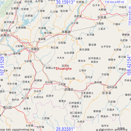
Shuanghe GPS coordinates[2]
29° 32' 57.552" North, 107° 43' 6.276" East
| Map corner | latitude | longitude |
|---|---|---|
| Upper-left | 30.15913°, | 107.01529° |
| Center: | 29.54932°, | 107.71841° |
| Lower-right: | 28.93581°, | 108.42154° |
| Map W x H: | 136×136 km | = 84.5×84.5mi |
| max Lat: | 53.31946° ⇑59.2% North |
| Shuanghe: | 29.54932° |
| min Lat: | ⇓40.8% South 18.22056° |
| min Long | Shuanghe | max Long |
| 75.07348° | 107.71841° | 134.28917° |
| W 18.5%⇐ | ⇒81.5% E |
Elevation
Elevation of Shuanghe is 1350 m = 4429 ft, and this is 865.2 m = 2839 ft above average elevation for this country.
| Max E: |
5622 m = 18445 ft | 10.1% |
| Shuanghe | 1350 m 4429 ft | |
| Avg. | 484.8 m = 1591 ft | |
Min E: |
-3 m = -10 ft | 89.9% |
See also: China elevation on elevation.city.
Geographical zone
Shuanghe is located in North temperate zone (between Tropic of Cancer and the Arctic Circle). Distance of this Northern Tropic circle is 679.7 km =422.3 mi to South.| Distance of | km | miles | from Shuanghe |
|---|---|---|---|
| North Pole | 6721.5 | 4176.5 | to North |
| Arctic Circle | 4115.6 | 2557.3 | to North |
| Tropic Cancer | 679.7 | 422.3 | to South |
| Equator | 3285.6 | 2041.6 | to South |


Nearby cities:
15 places around Shuanghe: (largest is in red/bold)
• Baima
24 km =14.9 mi,  227°
227°
• Baitao
22.4 km =13.9 mi,  270°
270°
• Baoluan
24.2 km =15 mi,  350°
350°
• Damu
9.4 km =5.8 mi,  325°
325°
• Huolu
22.8 km =14.2 mi,  139°
139°
• Jiaoshi
21.9 km =13.6 mi, 327°
• Jielong
17.8 km =11.1 mi,  72°
72°
• Nantianhu
25.8 km =16 mi,  49°
49°
• Sanba
14.2 km =8.8 mi,  15°
15°
• Shanwo
16.1 km =10 mi,  295°
295°
• Tongzi
22.5 km =14 mi,  87°
87°
• Tudi
18.2 km =11.3 mi,  105°
105°
• Wulongshan
15.5 km =9.6 mi,  262°
262°
• Xiangkou
24.4 km =15.2 mi,  175°
175°
• Yangjiao
20 km =12.4 mi,  212°
212°
Sources, notices
• [Note1] Compared only with cities in China existing in our database
• [Src1] Map data: © OpenStreetMap contributors (CC-BY-SA)
• [Src2] Other city data from geonames.org with taken over terms of usage.
• [Src3] Geographical zone / Annual Mean Temperature by Robert A. Rohde @ Wikipedia
