Xiangkou geodata
Xiangkou (Chongqing) is a seat of a third-order administrative division; located in China in Asia/Shanghai (GMT+8) time zone. In our database, there are 1268 cities with bigger population. Compared to other cities in China, 61.6% of cities are located further ↑North; 81.4% of cities are located further →East and 54.8% of cities have lower elevation than Xiangkou. Note1


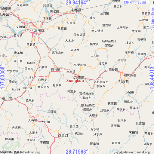
Xiangkou GPS coordinates[2]
29° 19' 49.8" North, 107° 44' 13.2" East
| Map corner | latitude | longitude |
|---|---|---|
| Upper-left | 29.94164°, | 107.03388° |
| Center: | 29.3305°, | 107.737° |
| Lower-right: | 28.71568°, | 108.44013° |
| Map W x H: | 136.3×136.3 km | = 84.7×84.7mi |
| max Lat: | 53.31946° ⇑61.6% North |
| Xiangkou: | 29.3305° |
| min Lat: | ⇓38.4% South 18.22056° |
| min Long | Xiangkou | max Long |
| 75.07348° | 107.737° | 134.28917° |
| W 18.6%⇐ | ⇒81.4% E |
Elevation
Elevation of Xiangkou is 205 m = 673 ft, and this is 279.8 m = 918 ft below average elevation for this country.
| Max E: |
5622 m = 18445 ft | 45.2% |
| Avg. | 484.8 m = 1591 ft | |
| Xiangkou | 205 m = 673 ft | |
Min E: |
-3 m = -10 ft | 54.8% |
See also: China elevation on elevation.city.
Geographical zone
Xiangkou is located in North temperate zone (between Tropic of Cancer and the Arctic Circle). Distance of this Northern Tropic circle is 655.3 km =407.2 mi to South.| Distance of | km | miles | from Xiangkou |
|---|---|---|---|
| North Pole | 6745.8 | 4191.6 | to North |
| Arctic Circle | 4139.9 | 2572.4 | to North |
| Tropic Cancer | 655.3 | 407.2 | to South |
| Equator | 3261.2 | 2026.4 | to South |


Nearby cities:
15 places around Xiangkou: (largest is in red/bold)
• Baima
21.2 km =13.2 mi,  292°
292°
• Canggou
26 km =16.2 mi,  60°
60°
• Changba
25.4 km =15.8 mi,  271°
271°
• Haokou
28 km =17.4 mi,  160°
160°
• Huangying
13.9 km =8.6 mi,  201°
201°
• Huolu
14.9 km =9.3 mi, 61°
• Jiangkou
16.7 km =10.4 mi,  125°
125°
• Luolong
28.9 km =18 mi,  187°
187°
• Shiqiao
17.2 km =10.7 mi,  148°
148°
• Shuanghe
24.4 km =15.2 mi,  355°
355°
• Tudi
25 km =15.5 mi,  39°
39°
• Wenfu
21.6 km =13.4 mi,  105°
105°
• Wulongshan
28.1 km =17.5 mi,  322°
322°
• Yangjiao
14.7 km =9.1 mi,  300°
300°
• Zhaojia
19.5 km =12.1 mi,  248°
248°
Sources, notices
• [Note1] Compared only with cities in China existing in our database
• [Src1] Map data: © OpenStreetMap contributors (CC-BY-SA)
• [Src2] Other city data from geonames.org with taken over terms of usage.
• [Src3] Geographical zone / Annual Mean Temperature by Robert A. Rohde @ Wikipedia
