Kuantian geodata
Kuantian (Jiangxi) is a seat of a fourth-order administrative division; located in China in Asia/Shanghai (GMT+8) time zone. In our database, there are 1268 cities with bigger population. Compared to other cities in China, 82.3% of cities are located further ↑North; 57.9% of cities are located further ←West and 54.8% of cities have lower elevation than Kuantian. Note1


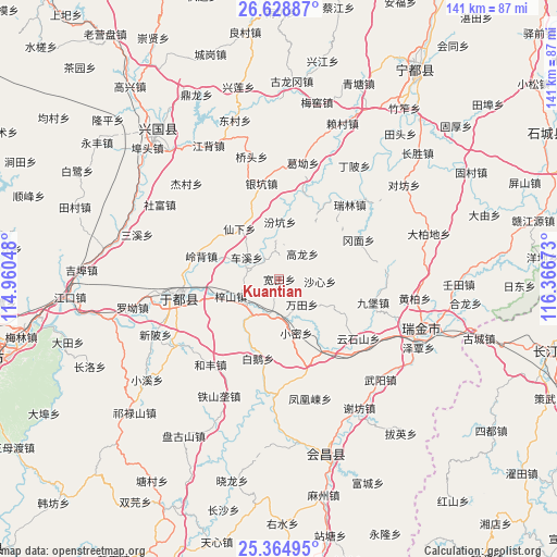
Kuantian GPS coordinates[2]
25° 59' 54.996" North, 115° 39' 48.96" East
| Map corner | latitude | longitude |
|---|---|---|
| Upper-left | 26.62887°, | 114.96048° |
| Center: | 25.99861°, | 115.6636° |
| Lower-right: | 25.36495°, | 116.36673° |
| Map W x H: | 140.5×140.5 km | = 87.3×87.3mi |
| max Lat: | 53.31946° ⇑82.3% North |
| Kuantian: | 25.99861° |
| min Lat: | ⇓17.7% South 18.22056° |
| min Long | Kuantian | max Long |
| 75.07348° | 115.6636° | 134.28917° |
| W 57.9%⇐ | ⇒42.1% E |
Elevation
Elevation of Kuantian is 204 m = 669 ft, and this is 280.8 m = 921 ft below average elevation for this country.
| Max E: |
5622 m = 18445 ft | 45.2% |
| Avg. | 484.8 m = 1591 ft | |
| Kuantian | 204 m = 669 ft | |
Min E: |
-3 m = -10 ft | 54.8% |
See also: China elevation on elevation.city.
Geographical zone
Kuantian is located in North temperate zone (between Tropic of Cancer and the Arctic Circle). Distance of this Northern Tropic circle is 284.9 km =177 mi to South.| Distance of | km | miles | from Kuantian |
|---|---|---|---|
| North Pole | 7116.3 | 4421.9 | to North |
| Arctic Circle | 4510.4 | 2802.6 | to North |
| Tropic Cancer | 284.9 | 177 | to South |
| Equator | 2890.8 | 1796.3 | to South |


Nearby cities:
15 places around Kuantian: (largest is in red/bold)
• Bai’e
20.7 km =12.9 mi,  195°
195°
• Chexi
9.9 km =6.2 mi,  303°
303°
• Fenkeng
14.5 km =9 mi,  0°
0°
• Gangmian
22.3 km =13.9 mi,  63°
63°
• Gaolong
8.7 km =5.4 mi,  42°
42°
• Huanglin
9.9 km =6.2 mi,  205°
205°
• Jiubao
24.4 km =15.2 mi,  103°
103°
• Lingbei
20.5 km =12.7 mi,  286°
286°
• Shaxin
10.3 km =6.4 mi,  93°
93°
• Wantian
8.6 km =5.3 mi,  137°
137°
• Xianxia
16.2 km =10.1 mi,  321°
321°
• Xiaomi
14.2 km =8.8 mi,  162°
162°
• Xijiang
21.4 km =13.3 mi,  146°
146°
• Yinkeng
24.6 km =15.3 mi,  348°
348°
• Zishan
13 km =8.1 mi,  250°
250°
Sources, notices
• [Note1] Compared only with cities in China existing in our database
• [Src1] Map data: © OpenStreetMap contributors (CC-BY-SA)
• [Src2] Other city data from geonames.org with taken over terms of usage.
• [Src3] Geographical zone / Annual Mean Temperature by Robert A. Rohde @ Wikipedia
