Songji geodata
Songji (Fujian) is a seat of a fourth-order administrative division; located in China in Asia/Shanghai (GMT+8) time zone. In our database, there are 1268 cities with bigger population. Compared to other cities in China, 80.2% of cities are located further ↑North; 74.6% of cities are located further ←West and 65.7% of cities have lower elevation than Songji. Note1


Songji GPS coordinates[2]
26° 34' 35.832" North, 118° 44' 25.26" East
| Map corner | latitude | longitude |
|---|---|---|
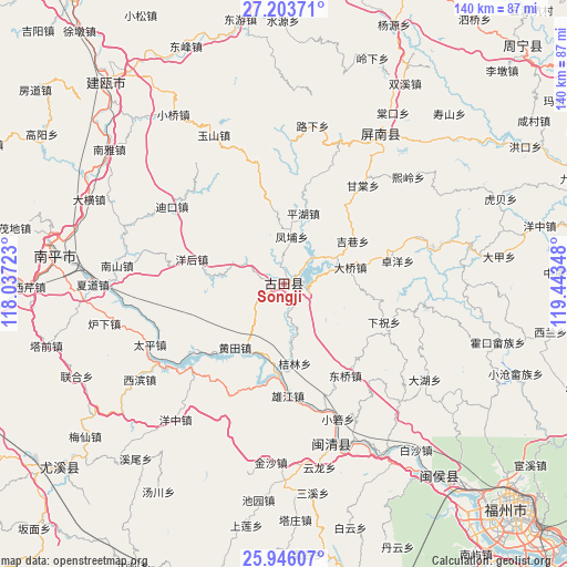
| Upper-left | 27.20371°, | 118.03723° |
| Center: | 26.57662°, | 118.74035° |
| Lower-right: | 25.94607°, | 119.44348° |
| Map W x H: | 139.8×139.8 km | = 86.9×86.9mi |
| max Lat: | 53.31946° ⇑80.2% North |
| Songji: | 26.57662° |
| min Lat: | ⇓19.8% South 18.22056° |
| min Long | Songji | max Long |
| 75.07348° | 118.74035° | 134.28917° |
| W 74.6%⇐ | ⇒25.4% E |
Elevation
Elevation of Songji is 338 m = 1109 ft, and this is 146.8 m = 482 ft below average elevation for this country.
| Max E: |
5622 m = 18445 ft | 34.3% |
| Avg. | 484.8 m = 1591 ft | |
| Songji | 338 m = 1109 ft | |
Min E: |
-3 m = -10 ft | 65.7% |
See also: China elevation on elevation.city.
Geographical zone
Songji is located in North temperate zone (between Tropic of Cancer and the Arctic Circle). Distance of this Northern Tropic circle is 349.1 km =216.9 mi to South.| Distance of | km | miles | from Songji |
|---|---|---|---|
| North Pole | 7052 | 4381.9 | to North |
| Arctic Circle | 4446.1 | 2762.7 | to North |
| Tropic Cancer | 349.1 | 216.9 | to South |
| Equator | 2955 | 1836.2 | to South |


Nearby cities:
15 places around Songji: (largest is in red/bold)
• Chengdong
0.3 km =0.2 mi,  321°
321°
• Daqiao
17.1 km =10.6 mi,  75°
75°
• Dongqiao
27.3 km =17 mi,  146°
146°
• Fengpu
12 km =7.5 mi,  9°
9°
• Hengyang
18.5 km =11.5 mi,  89°
89°
• Huangtian
19.2 km =11.9 mi,  217°
217°
• Jielin
19.7 km =12.2 mi,  171°
171°
• Jixiang
20.1 km =12.5 mi,  57°
57°
• Panyang
9.5 km =5.9 mi,  108°
108°
• Pinghu
18.6 km =11.6 mi,  16°
16°
• Shuangzhu
11.2 km =7 mi,  302°
302°
• Shuikou
21.5 km =13.4 mi,  182°
182°
• Xiazhu
26.5 km =16.5 mi, 110°
• Xiongjiang
26.9 km =16.7 mi, 179°
• Yanghou
24.2 km =15 mi,  287°
287°
Sources, notices
• [Note1] Compared only with cities in China existing in our database
• [Src1] Map data: © OpenStreetMap contributors (CC-BY-SA)
• [Src2] Other city data from geonames.org with taken over terms of usage.
• [Src3] Geographical zone / Annual Mean Temperature by Robert A. Rohde @ Wikipedia
