Menghai geodata
Menghai (Yunnan) is a seat of a third-order administrative division; located in China in Asia/Shanghai (GMT+8) time zone. In our database, there are 1268 cities with bigger population. Compared to other cities in China, 97.3% of cities are located further ↑North; 94.3% of cities are located further →East and 87.9% of cities have lower elevation than Menghai. Note1


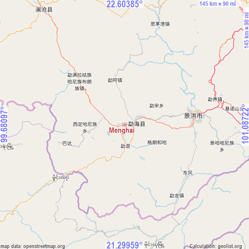
Menghai GPS coordinates[2]
21° 57' 11.592" North, 100° 23' 2.724" East
| Map corner | latitude | longitude |
|---|---|---|
| Upper-left | 22.60385°, | 99.68097° |
| Center: | 21.95322°, | 100.38409° |
| Lower-right: | 21.29959°, | 101.08722° |
| Map W x H: | 145×145 km | = 90.1×90.1mi |
| max Lat: | 53.31946° ⇑97.3% North |
| Menghai: | 21.95322° |
| min Lat: | ⇓2.7% South 18.22056° |
| min Long | Menghai | max Long |
| 75.07348° | 100.38409° | 134.28917° |
| W 5.7%⇐ | ⇒94.3% E |
Elevation
Elevation of Menghai is 1174 m = 3852 ft, and this is 689.2 m = 2261 ft above average elevation for this country.
| Max E: |
5622 m = 18445 ft | 12.1% |
| Menghai | 1174 m 3852 ft | |
| Avg. | 484.8 m = 1591 ft | |
Min E: |
-3 m = -10 ft | 87.9% |
See also: China elevation on elevation.city.
Geographical zone
Menghai is located in North Torrid zone (between Equator and Tropic of Cancer). Distance of this Northern Tropic circle is 164.9 km =102.5 mi to North.| Distance of | km | miles | from Menghai |
|---|---|---|---|
| North Pole | 7566.1 | 4701.4 | to North |
| Arctic Circle | 4960.2 | 3082.1 | to North |
| Tropic Cancer | 164.9 | 102.5 | to North |
| Equator | 2441 | 1516.8 | to South |


Nearby cities:
15 places around Menghai: (largest is in red/bold)
• Enle
234.4 km =145.6 mi,  17°
17°
• Gengma
202.7 km =126 mi,  329°
329°
• Jinghong
36.3 km =22.6 mi,  83°
83°
• Lianzhu
211.4 km =131.4 mi,  40°
40°
• Liushun
82.8 km =51.4 mi, 24°
• Mengdong
181 km =112.5 mi,  317°
317°
• Mengla
132 km =82 mi,  114°
114°
• Menglang
83.4 km =51.8 mi, 324°
• Menglie
166.9 km =103.7 mi,  66°
66°
• Mengmeng
178.4 km =110.9 mi,  340°
340°
• Mengsuo
112 km =69.6 mi,  310°
310°
• Nayun
94.6 km =58.8 mi,  296°
296°
• Ning’er
138.2 km =85.9 mi,  29°
29°
• Simao
111 km =69 mi, 33°
• Weiyuan
171.2 km =106.4 mi,  10°
10°
Sources, notices
• [Note1] Compared only with cities in China existing in our database
• [Src1] Map data: © OpenStreetMap contributors (CC-BY-SA)
• [Src2] Other city data from geonames.org with taken over terms of usage.
• [Src3] Geographical zone / Annual Mean Temperature by Robert A. Rohde @ Wikipedia
