Simao geodata
Simao (Yunnan) is a seat of a third-order administrative division; located in China in Asia/Shanghai (GMT+8) time zone. In our database, there are 1268 cities with bigger population. Compared to other cities in China, 95.3% of cities are located further ↑North; 93.8% of cities are located further →East and 89.7% of cities have lower elevation than Simao. Note1


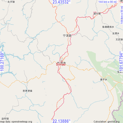
Simao GPS coordinates[2]
22° 47' 19.068" North, 100° 58' 29.316" East
| Map corner | latitude | longitude |
|---|---|---|
| Upper-left | 23.43532°, | 100.27169° |
| Center: | 22.78863°, | 100.97481° |
| Lower-right: | 22.13886°, | 101.67794° |
| Map W x H: | 144.2×144.2 km | = 89.6×89.6mi |
| max Lat: | 53.31946° ⇑95.3% North |
| Simao: | 22.78863° |
| min Lat: | ⇓4.7% South 18.22056° |
| min Long | Simao | max Long |
| 75.07348° | 100.97481° | 134.28917° |
| W 6.2%⇐ | ⇒93.8% E |
Elevation
Elevation of Simao is 1331 m = 4367 ft, and this is 846.2 m = 2776 ft above average elevation for this country.
| Max E: |
5622 m = 18445 ft | 10.3% |
| Simao | 1331 m 4367 ft | |
| Avg. | 484.8 m = 1591 ft | |
Min E: |
-3 m = -10 ft | 89.7% |
See also: China elevation on elevation.city.
Geographical zone
Simao is located in North Torrid zone (between Equator and Tropic of Cancer). Distance of this Northern Tropic circle is 72.1 km =44.8 mi to North.| Distance of | km | miles | from Simao |
|---|---|---|---|
| North Pole | 7473.2 | 4643.6 | to North |
| Arctic Circle | 4867.3 | 3024.4 | to North |
| Tropic Cancer | 72.1 | 44.8 | to North |
| Equator | 2533.9 | 1574.5 | to South |


Nearby cities:
15 places around Simao: (largest is in red/bold)
• Daxing
148 km =92 mi,  82°
82°
• Enle
130.8 km =81.3 mi,  4°
4°
• Jinghong
92.1 km =57.2 mi,  195°
195°
• Lianzhu
102 km =63.4 mi,  47°
47°
• Lijiang
136.5 km =84.8 mi, 50°
• Liushun
31.3 km =19.4 mi,  235°
235°
• Menghai
111 km =69 mi,  213°
213°
• Mengla
158.3 km =98.4 mi,  157°
157°
• Menglang
112.1 km =69.7 mi,  257°
257°
• Menglie
95.1 km =59.1 mi,  105°
105°
• Mengmeng
141.5 km =87.9 mi,  302°
302°
• Mengsuo
147.5 km =91.7 mi, 261°
• Nayun
153.8 km =95.6 mi,  250°
250°
• Ning’er
28.7 km =17.8 mi,  12°
12°
• Weiyuan
81.2 km =50.5 mi,  338°
338°
Sources, notices
• [Note1] Compared only with cities in China existing in our database
• [Src1] Map data: © OpenStreetMap contributors (CC-BY-SA)
• [Src2] Other city data from geonames.org with taken over terms of usage.
• [Src3] Geographical zone / Annual Mean Temperature by Robert A. Rohde @ Wikipedia
