Menglie geodata
Menglie (Yunnan) is a seat of a third-order administrative division; located in China in Asia/Shanghai (GMT+8) time zone. In our database, there are 1268 cities with bigger population. Compared to other cities in China, 96.2% of cities are located further ↑North; 93% of cities are located further →East and 88.2% of cities have lower elevation than Menglie. Note1


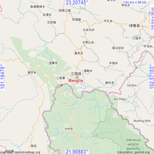
Menglie GPS coordinates[2]
22° 33' 34.812" North, 101° 52' 4.44" East
| Map corner | latitude | longitude |
|---|---|---|
| Upper-left | 23.20745°, | 101.16478° |
| Center: | 22.55967°, | 101.8679° |
| Lower-right: | 21.90883°, | 102.57103° |
| Map W x H: | 144.4×144.4 km | = 89.7×89.7mi |
| max Lat: | 53.31946° ⇑96.2% North |
| Menglie: | 22.55967° |
| min Lat: | ⇓3.8% South 18.22056° |
| min Long | Menglie | max Long |
| 75.07348° | 101.8679° | 134.28917° |
| W 7%⇐ | ⇒93% E |
Elevation
Elevation of Menglie is 1202 m = 3944 ft, and this is 717.2 m = 2353 ft above average elevation for this country.
| Max E: |
5622 m = 18445 ft | 11.8% |
| Menglie | 1202 m 3944 ft | |
| Avg. | 484.8 m = 1591 ft | |
Min E: |
-3 m = -10 ft | 88.2% |
See also: China elevation on elevation.city.
Geographical zone
Menglie is located in North Torrid zone (between Equator and Tropic of Cancer). Distance of this Northern Tropic circle is 97.5 km =60.6 mi to North.| Distance of | km | miles | from Menglie |
|---|---|---|---|
| North Pole | 7498.7 | 4659.5 | to North |
| Arctic Circle | 4892.8 | 3040.2 | to North |
| Tropic Cancer | 97.5 | 60.6 | to North |
| Equator | 2508.4 | 1558.6 | to South |


Nearby cities:
15 places around Menglie: (largest is in red/bold)
• Daxing
71.5 km =44.4 mi,  50°
50°
• Gejiu
159 km =98.8 mi,  55°
55°
• Jinghong
132.7 km =82.5 mi,  241°
241°
• Jinhe
143.7 km =89.3 mi,  80°
80°
• Lianzhu
95.7 km =59.5 mi,  350°
350°
• Lijiang
113.3 km =70.4 mi,  7°
7°
• Lin’an
152.1 km =94.5 mi,  40°
40°
• Liushun
117.7 km =73.1 mi,  273°
273°
• Mengla
125.6 km =78 mi,  195°
195°
• Nansha
120.6 km =74.9 mi, 55°
• Ning’er
100.6 km =62.5 mi,  302°
302°
• Simao
95.1 km =59.1 mi,  285°
285°
• Weiyuan
157.8 km =98.1 mi,  309°
309°
• Yilong
140.9 km =87.6 mi,  26°
26°
• Yisa
104.4 km =64.9 mi, 34°
In other languages:
- In Chinese: Chiang-ch’eng, Chiang-ch’eng-hsien, Chiang-ch’eng-ha-ni-tsu-i-tsu-tzu-chih-hsien, 勐烈
Sources, notices
• [Note1] Compared only with cities in China existing in our database
• [Src1] Map data: © OpenStreetMap contributors (CC-BY-SA)
• [Src2] Other city data from geonames.org with taken over terms of usage.
• [Src3] Geographical zone / Annual Mean Temperature by Robert A. Rohde @ Wikipedia
