Weifang geodata
Weifang (Shandong) is a populated place; located in China in Asia/Shanghai (GMT+8) time zone. With population of 394,732 people, there are 153 cities with bigger population in this country. Compared to other cities in China, 78.6% of cities are located further ↓South; 76.6% of cities are located further ←West and 78.3% of cities have higher elevation than Weifang. Note1


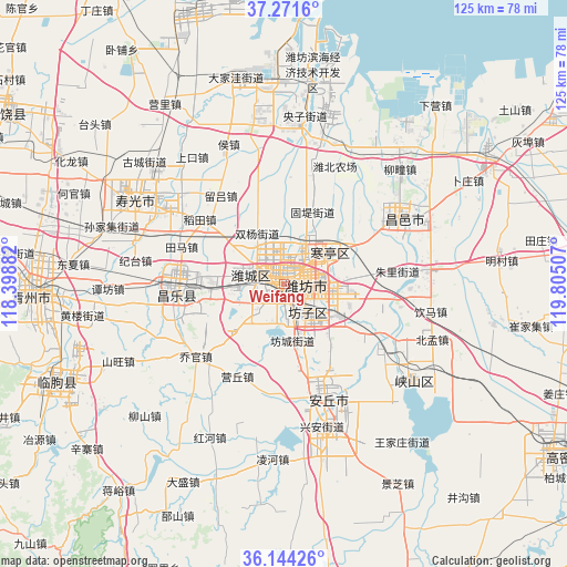
Weifang GPS coordinates[2]
36° 42' 36" North, 119° 6' 6.984" East
| Map corner | latitude | longitude |
|---|---|---|
| Upper-left | 37.2716°, | 118.39882° |
| Center: | 36.71°, | 119.10194° |
| Lower-right: | 36.14426°, | 119.80507° |
| Map W x H: | 125.3×125.3 km | = 77.9×77.9mi |
| max Lat: | 53.31946° ⇑21.4% North |
| Weifang: | 36.71° |
| min Lat: | ⇓78.6% South 18.22056° |
| min Long | Weifang | max Long |
| 75.07348° | 119.10194° | 134.28917° |
| W 76.6%⇐ | ⇒23.4% E |
Elevation
Elevation of Weifang is 30 m = 98 ft, and this is 454.8 m = 1492 ft below average elevation for this country.
| Max E: |
5622 m = 18445 ft | 78.3% |
| Avg. | 484.8 m = 1591 ft | |
| Weifang | 30 m = 98 ft | |
Min E: |
-3 m = -10 ft | 21.7% |
See also: Weifang elevation on elevation.city.
Geographical zone
Weifang is located in North temperate zone (between Tropic of Cancer and the Arctic Circle). Distance of this Northern Tropic circle is 1475.9 km =917.1 mi to South.| Distance of | km | miles | from Weifang |
|---|---|---|---|
| North Pole | 5925.3 | 3681.8 | to North |
| Arctic Circle | 3319.4 | 2062.6 | to North |
| Tropic Cancer | 1475.9 | 917.1 | to South |
| Equator | 4081.8 | 2536.3 | to South |


Nearby cities:
15 places around Weifang: (largest is in red/bold)
• Anqiu
31.7 km =19.7 mi,  165°
165°
• Gaomi
68.6 km =42.6 mi,  121°
121°
• Guangrao
73.2 km =45.5 mi,  301°
301°
• Hanting
11.8 km =7.3 mi,  55°
55°
• Kuiju
30.3 km =18.8 mi, 58°
• Linqu
54.6 km =33.9 mi,  246°
246°
• Longhuya
82.7 km =51.4 mi, 55°
• Pingdu
75.7 km =47 mi,  83°
83°
• Qingzhou
55.5 km =34.5 mi,  268°
268°
• Shahe
69.8 km =43.4 mi, 58°
• Shouguang
37.6 km =23.4 mi, 300°
• Tushan
63.8 km =39.6 mi,  52°
52°
• Xiaqiu
78.5 km =48.8 mi,  65°
65°
• Xindian
72.6 km =45.1 mi,  277°
277°
• Yangzi
37.5 km =23.3 mi,  7°
7°
Sources, notices
• [Note1] Compared only with cities in China existing in our database
• [Src1] Map data: © OpenStreetMap contributors (CC-BY-SA)
• [Src2] Other city data from geonames.org with taken over terms of usage.
• [Src3] Geographical zone / Annual Mean Temperature by Robert A. Rohde @ Wikipedia
