Yangzi geodata
Yangzi (Shandong) is a seat of a fourth-order administrative division; located in China in Asia/Shanghai (GMT+8) time zone. In our database, there are 1268 cities with bigger population. Compared to other cities in China, 79.3% of cities are located further ↓South; 76.8% of cities are located further ←West and 98.9% of cities have higher elevation than Yangzi. Note1


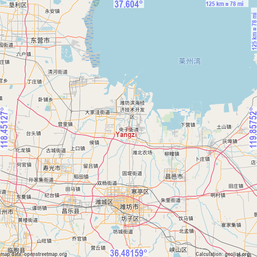
Yangzi GPS coordinates[2]
37° 2' 41.532" North, 119° 9' 15.804" East
| Map corner | latitude | longitude |
|---|---|---|
| Upper-left | 37.604°, | 118.45127° |
| Center: | 37.04487°, | 119.15439° |
| Lower-right: | 36.48159°, | 119.85752° |
| Map W x H: | 124.8×124.8 km | = 77.5×77.5mi |
| max Lat: | 53.31946° ⇑20.7% North |
| Yangzi: | 37.04487° |
| min Lat: | ⇓79.3% South 18.22056° |
| min Long | Yangzi | max Long |
| 75.07348° | 119.15439° | 134.28917° |
| W 76.8%⇐ | ⇒23.2% E |
Elevation
Elevation of Yangzi is 3 m = 10 ft, and this is 481.8 m = 1581 ft below average elevation for this country.
| Max E: |
5622 m = 18445 ft | 98.9% |
| Avg. | 484.8 m = 1591 ft | |
| Yangzi | 3 m = 10 ft | |
Min E: |
-3 m = -10 ft | 1.1% |
See also: China elevation on elevation.city.
Geographical zone
Yangzi is located in North temperate zone (between Tropic of Cancer and the Arctic Circle). Distance of this Northern Tropic circle is 1513.1 km =940.2 mi to South.| Distance of | km | miles | from Yangzi |
|---|---|---|---|
| North Pole | 5888.1 | 3658.7 | to North |
| Arctic Circle | 3282.2 | 2039.5 | to North |
| Tropic Cancer | 1513.1 | 940.2 | to South |
| Equator | 4119 | 2559.4 | to South |


Nearby cities:
15 places around Yangzi: (largest is in red/bold)
• Anqiu
68 km =42.3 mi,  177°
177°
• Guangrao
65.7 km =40.8 mi,  291°
291°
• Guangrao
67 km =41.6 mi,  270°
270°
• Hanting
30.9 km =19.2 mi,  170°
170°
• Kuiju
29.9 km =18.6 mi,  135°
135°
• Laizhou
71.5 km =44.4 mi,  77°
77°
• Longhuya
64.1 km =39.8 mi, 81°
• Qingzhou
71.4 km =44.4 mi,  237°
237°
• Shahe
54.6 km =33.9 mi,  90°
90°
• Shouguang
41.3 km =25.7 mi, 243°
• Tushan
46.2 km =28.7 mi, 88°
• Weifang
37.5 km =23.3 mi,  187°
187°
• Wenfenglu
69.2 km =43 mi, 82°
• Xiaqiu
66.5 km =41.3 mi, 93°
• Zuocun
69.9 km =43.4 mi, 88°
Sources, notices
• [Note1] Compared only with cities in China existing in our database
• [Src1] Map data: © OpenStreetMap contributors (CC-BY-SA)
• [Src2] Other city data from geonames.org with taken over terms of usage.
• [Src3] Geographical zone / Annual Mean Temperature by Robert A. Rohde @ Wikipedia
