Shouguang geodata
Shouguang (Shandong) is a populated place; located in China in Asia/Shanghai (GMT+8) time zone. With population of 79,212 people, there are 536 cities with bigger population in this country. Compared to other cities in China, 78.9% of cities are located further ↓South; 74.6% of cities are located further ←West and 80.2% of cities have higher elevation than Shouguang. Note1


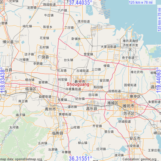
Shouguang GPS coordinates[2]
36° 52' 48" North, 118° 44' 15" East
| Map corner | latitude | longitude |
|---|---|---|
| Upper-left | 37.44035°, | 118.03438° |
| Center: | 36.88°, | 118.7375° |
| Lower-right: | 36.31551°, | 119.44063° |
| Map W x H: | 125.1×125.1 km | = 77.7×77.7mi |
| max Lat: | 53.31946° ⇑21.1% North |
| Shouguang: | 36.88° |
| min Lat: | ⇓78.9% South 18.22056° |
| min Long | Shouguang | max Long |
| 75.07348° | 118.7375° | 134.28917° |
| W 74.6%⇐ | ⇒25.4% E |
Elevation
Elevation of Shouguang is 26 m = 85 ft, and this is 458.8 m = 1505 ft below average elevation for this country.
| Max E: |
5622 m = 18445 ft | 80.2% |
| Avg. | 484.8 m = 1591 ft | |
| Shouguang | 26 m = 85 ft | |
Min E: |
-3 m = -10 ft | 19.8% |
See also: Shouguang elevation on elevation.city.
Geographical zone
Shouguang is located in North temperate zone (between Tropic of Cancer and the Arctic Circle). Distance of this Northern Tropic circle is 1494.8 km =928.8 mi to South.| Distance of | km | miles | from Shouguang |
|---|---|---|---|
| North Pole | 5906.4 | 3670.1 | to North |
| Arctic Circle | 3300.5 | 2050.8 | to North |
| Tropic Cancer | 1494.8 | 928.8 | to South |
| Equator | 4100.7 | 2548.1 | to South |


Nearby cities:
15 places around Shouguang: (largest is in red/bold)
• Anqiu
64.1 km =39.8 mi,  140°
140°
• Dongping
78.5 km =48.8 mi,  237°
237°
• Guangrao
35.7 km =22.2 mi,  302°
302°
• Guangrao
48.7 km =30.3 mi,  330°
330°
• Hanting
43.8 km =27.2 mi,  106°
106°
• Kuiju
58.2 km =36.2 mi,  92°
92°
• Linqu
44.2 km =27.5 mi,  203°
203°
• Nanding
62.4 km =38.8 mi,  256°
256°
• Qingzhou
30.7 km =19.1 mi,  228°
228°
• Shengli
68.4 km =42.5 mi,  341°
341°
• Suozhen
56.8 km =35.3 mi,  278°
278°
• Weifang
37.6 km =23.4 mi,  120°
120°
• Xindian
40.5 km =25.2 mi, 256°
• Yangzi
41.3 km =25.7 mi,  63°
63°
• Zibo
60.8 km =37.8 mi, 260°
Sources, notices
• [Note1] Compared only with cities in China existing in our database
• [Src1] Map data: © OpenStreetMap contributors (CC-BY-SA)
• [Src2] Other city data from geonames.org with taken over terms of usage.
• [Src3] Geographical zone / Annual Mean Temperature by Robert A. Rohde @ Wikipedia
