Hanting geodata
Hanting (Shandong) is a populated place; located in China in Asia/Shanghai (GMT+8) time zone. With population of 90,637 people, there are 468 cities with bigger population in this country. Compared to other cities in China, 78.7% of cities are located further ↓South; 77.1% of cities are located further ←West and 83.9% of cities have higher elevation than Hanting. Note1


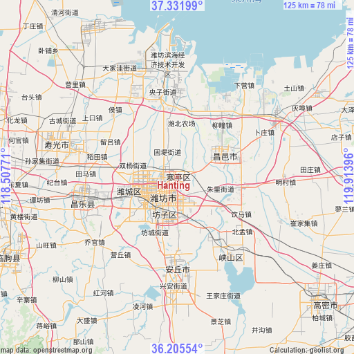
Hanting GPS coordinates[2]
36° 46' 14.988" North, 119° 12' 38.988" East
| Map corner | latitude | longitude |
|---|---|---|
| Upper-left | 37.33199°, | 118.50771° |
| Center: | 36.77083°, | 119.21083° |
| Lower-right: | 36.20554°, | 119.91396° |
| Map W x H: | 125.2×125.2 km | = 77.8×77.8mi |
| max Lat: | 53.31946° ⇑21.3% North |
| Hanting: | 36.77083° |
| min Lat: | ⇓78.7% South 18.22056° |
| min Long | Hanting | max Long |
| 75.07348° | 119.21083° | 134.28917° |
| W 77.1%⇐ | ⇒22.9% E |
Elevation
Elevation of Hanting is 18 m = 59 ft, and this is 466.8 m = 1531 ft below average elevation for this country.
| Max E: |
5622 m = 18445 ft | 83.9% |
| Avg. | 484.8 m = 1591 ft | |
| Hanting | 18 m = 59 ft | |
Min E: |
-3 m = -10 ft | 16.1% |
See also: Hanting elevation on elevation.city.
Geographical zone
Hanting is located in North temperate zone (between Tropic of Cancer and the Arctic Circle). Distance of this Northern Tropic circle is 1482.6 km =921.2 mi to South.| Distance of | km | miles | from Hanting |
|---|---|---|---|
| North Pole | 5918.5 | 3677.6 | to North |
| Arctic Circle | 3312.6 | 2058.4 | to North |
| Tropic Cancer | 1482.6 | 921.2 | to South |
| Equator | 4088.5 | 2540.5 | to South |


Nearby cities:
15 places around Hanting: (largest is in red/bold)
• Anqiu
37.5 km =23.3 mi,  182°
182°
• Gaomi
64.8 km =40.3 mi,  131°
131°
• Kuiju
18.5 km =11.5 mi,  60°
60°
• Linqu
66.3 km =41.2 mi,  244°
244°
• Longhuya
70.9 km =44.1 mi, 55°
• Pingdu
65.5 km =40.7 mi,  88°
88°
• Qingzhou
65.7 km =40.8 mi,  262°
262°
• Shahe
57.9 km =36 mi, 59°
• Shouguang
43.8 km =27.2 mi,  286°
286°
• Tushan
52 km =32.3 mi,  52°
52°
• Weifang
11.8 km =7.3 mi, 235°
• Wenfenglu
75 km =46.6 mi, 58°
• Xiaqiu
66.9 km =41.6 mi,  66°
66°
• Yangzi
30.9 km =19.2 mi,  350°
350°
• Zuocun
72.5 km =45 mi, 63°
Sources, notices
• [Note1] Compared only with cities in China existing in our database
• [Src1] Map data: © OpenStreetMap contributors (CC-BY-SA)
• [Src2] Other city data from geonames.org with taken over terms of usage.
• [Src3] Geographical zone / Annual Mean Temperature by Robert A. Rohde @ Wikipedia
