Tongzi geodata
Tongzi (Chongqing) is a seat of a fourth-order administrative division; located in China in Asia/Shanghai (GMT+8) time zone. In our database, there are 1268 cities with bigger population. Compared to other cities in China, 59.1% of cities are located further ↑North; 80.7% of cities are located further →East and 86.7% of cities have lower elevation than Tongzi. Note1


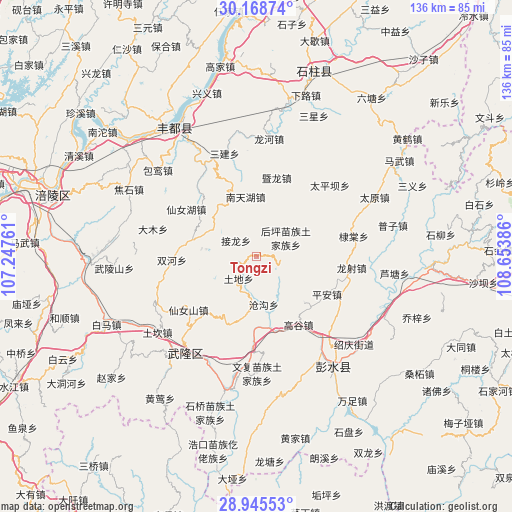
Tongzi GPS coordinates[2]
29° 33' 32.364" North, 107° 57' 2.628" East
| Map corner | latitude | longitude |
|---|---|---|
| Upper-left | 30.16874°, | 107.24761° |
| Center: | 29.55899°, | 107.95073° |
| Lower-right: | 28.94553°, | 108.65386° |
| Map W x H: | 136×136 km | = 84.5×84.5mi |
| max Lat: | 53.31946° ⇑59.1% North |
| Tongzi: | 29.55899° |
| min Lat: | ⇓40.9% South 18.22056° |
| min Long | Tongzi | max Long |
| 75.07348° | 107.95073° | 134.28917° |
| W 19.3%⇐ | ⇒80.7% E |
Elevation
Elevation of Tongzi is 1094 m = 3589 ft, and this is 609.2 m = 1999 ft above average elevation for this country.
| Max E: |
5622 m = 18445 ft | 13.3% |
| Tongzi | 1094 m 3589 ft | |
| Avg. | 484.8 m = 1591 ft | |
Min E: |
-3 m = -10 ft | 86.7% |
See also: China elevation on elevation.city.
Geographical zone
Tongzi is located in North temperate zone (between Tropic of Cancer and the Arctic Circle). Distance of this Northern Tropic circle is 680.7 km =423 mi to South.| Distance of | km | miles | from Tongzi |
|---|---|---|---|
| North Pole | 6720.4 | 4175.9 | to North |
| Arctic Circle | 4114.5 | 2556.6 | to North |
| Tropic Cancer | 680.7 | 423 | to South |
| Equator | 3286.7 | 2042.3 | to South |


Nearby cities:
15 places around Tongzi: (largest is in red/bold)
• Canggou
12.6 km =7.8 mi,  171°
171°
• Ditang
26.3 km =16.3 mi,  78°
78°
• Dudu
17.8 km =11.1 mi,  62°
62°
• Gaogu
21.3 km =13.2 mi,  148°
148°
• Houping
9 km =5.6 mi, 57°
• Huolu
19.8 km =12.3 mi,  202°
202°
• Jielong
6.8 km =4.2 mi,  307°
307°
• Jilong
19 km =11.8 mi,  16°
16°
• Longshe
25.4 km =15.8 mi,  97°
97°
• Luwu
17.7 km =11 mi,  134°
134°
• Nantianhu
16.1 km =10 mi,  349°
349°
• Ping’an
21.3 km =13.2 mi,  118°
118°
• Sanba
22.5 km =14 mi,  304°
304°
• Shuanghe
22.5 km =14 mi,  267°
267°
• Tudi
7.8 km =4.8 mi,  219°
219°
Sources, notices
• [Note1] Compared only with cities in China existing in our database
• [Src1] Map data: © OpenStreetMap contributors (CC-BY-SA)
• [Src2] Other city data from geonames.org with taken over terms of usage.
• [Src3] Geographical zone / Annual Mean Temperature by Robert A. Rohde @ Wikipedia
