Nantianhu geodata
Nantianhu (Chongqing) is a seat of a fourth-order administrative division; located in China in Asia/Shanghai (GMT+8) time zone. In our database, there are 1268 cities with bigger population. Compared to other cities in China, 57.5% of cities are located further ↑North; 80.8% of cities are located further →East and 87.2% of cities have lower elevation than Nantianhu. Note1


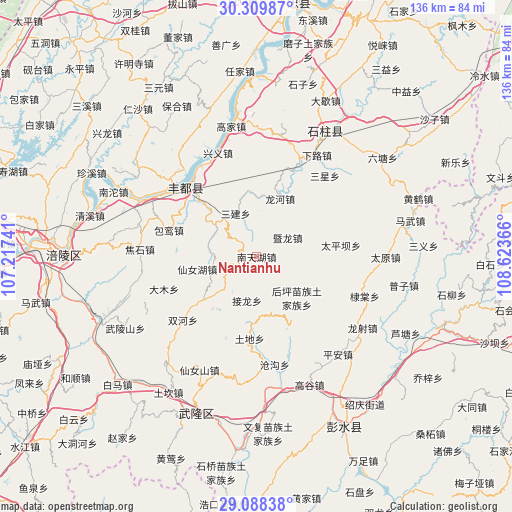
Nantianhu GPS coordinates[2]
29° 42' 3.528" North, 107° 55' 13.908" East
| Map corner | latitude | longitude |
|---|---|---|
| Upper-left | 30.30987°, | 107.21741° |
| Center: | 29.70098°, | 107.92053° |
| Lower-right: | 29.08838°, | 108.62366° |
| Map W x H: | 135.8×135.8 km | = 84.4×84.4mi |
| max Lat: | 53.31946° ⇑57.5% North |
| Nantianhu: | 29.70098° |
| min Lat: | ⇓42.5% South 18.22056° |
| min Long | Nantianhu | max Long |
| 75.07348° | 107.92053° | 134.28917° |
| W 19.2%⇐ | ⇒80.8% E |
Elevation
Elevation of Nantianhu is 1131 m = 3711 ft, and this is 646.2 m = 2120 ft above average elevation for this country.
| Max E: |
5622 m = 18445 ft | 12.8% |
| Nantianhu | 1131 m 3711 ft | |
| Avg. | 484.8 m = 1591 ft | |
Min E: |
-3 m = -10 ft | 87.2% |
See also: China elevation on elevation.city.
Geographical zone
Nantianhu is located in North temperate zone (between Tropic of Cancer and the Arctic Circle). Distance of this Northern Tropic circle is 696.5 km =432.8 mi to South.| Distance of | km | miles | from Nantianhu |
|---|---|---|---|
| North Pole | 6704.6 | 4166 | to North |
| Arctic Circle | 4098.7 | 2546.8 | to North |
| Tropic Cancer | 696.5 | 432.8 | to South |
| Equator | 3302.4 | 2052 | to South |


Nearby cities:
15 places around Nantianhu: (largest is in red/bold)
• Baoluan
24.4 km =15.2 mi,  286°
286°
• Dudu
20.2 km =12.6 mi,  112°
112°
• Houping
15.2 km =9.4 mi,  136°
136°
• Jiangchi
25.8 km =16 mi,  23°
23°
• Jielong
11.9 km =7.4 mi,  192°
192°
• Jilong
8.5 km =5.3 mi,  73°
73°
• Lizi
12.3 km =7.6 mi,  1°
1°
• Longhe
16.6 km =10.3 mi, 22°
• Sanba
16 km =9.9 mi,  258°
258°
• Sanjian
12.8 km =8 mi,  334°
334°
• Shuanglu
23 km =14.3 mi,  322°
322°
• Taipingba
22.6 km =14 mi,  81°
81°
• Tongzi
16.1 km =10 mi,  169°
169°
• Tudi
21.9 km =13.6 mi, 185°
• Wuping
19.1 km =11.9 mi,  56°
56°
Sources, notices
• [Note1] Compared only with cities in China existing in our database
• [Src1] Map data: © OpenStreetMap contributors (CC-BY-SA)
• [Src2] Other city data from geonames.org with taken over terms of usage.
• [Src3] Geographical zone / Annual Mean Temperature by Robert A. Rohde @ Wikipedia
