Pingxiang geodata
Pingxiang (Gansu) is a seat of a third-order administrative division; located in China in Asia/Shanghai (GMT+8) time zone. In our database, there are 1268 cities with bigger population. Compared to other cities in China, 75.5% of cities are located further ↓South; 88.7% of cities are located further →East and 93.4% of cities have lower elevation than Pingxiang. Note1


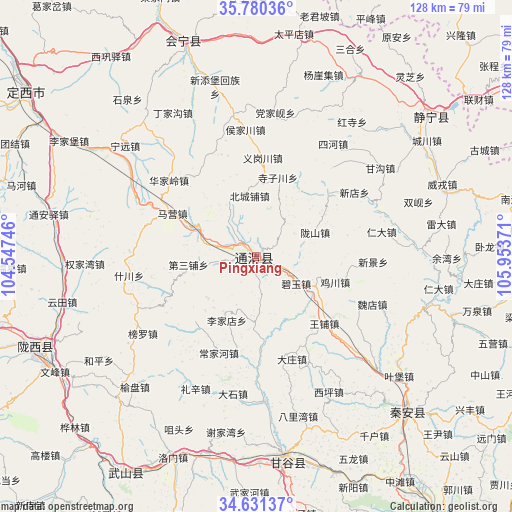
Pingxiang GPS coordinates[2]
35° 12' 28.44" North, 105° 15' 2.088" East
| Map corner | latitude | longitude |
|---|---|---|
| Upper-left | 35.78036°, | 104.54746° |
| Center: | 35.2079°, | 105.25058° |
| Lower-right: | 34.63137°, | 105.95371° |
| Map W x H: | 127.8×127.8 km | = 79.4×79.4mi |
| max Lat: | 53.31946° ⇑24.5% North |
| Pingxiang: | 35.2079° |
| min Lat: | ⇓75.5% South 18.22056° |
| min Long | Pingxiang | max Long |
| 75.07348° | 105.25058° | 134.28917° |
| W 11.3%⇐ | ⇒88.7% E |
Elevation
Elevation of Pingxiang is 1778 m = 5833 ft, and this is 1293.2 m = 4243 ft above average elevation for this country.
| Max E: |
5622 m = 18445 ft | 6.6% |
| Pingxiang | 1778 m 5833 ft | |
| Avg. | 484.8 m = 1591 ft | |
Min E: |
-3 m = -10 ft | 93.4% |
See also: China elevation on elevation.city.
Geographical zone
Pingxiang is located in North temperate zone (between Tropic of Cancer and the Arctic Circle). Distance of this Northern Tropic circle is 1308.8 km =813.3 mi to South.| Distance of | km | miles | from Pingxiang |
|---|---|---|---|
| North Pole | 6092.3 | 3785.6 | to North |
| Arctic Circle | 3486.4 | 2166.3 | to North |
| Tropic Cancer | 1308.8 | 813.3 | to South |
| Equator | 3914.8 | 2432.5 | to South |


Nearby cities:
15 places around Pingxiang: (largest is in red/bold)
• Dangjiaxian
36.1 km =22.4 mi,  7°
7°
• Gangu Chengguanzhen
53 km =32.9 mi,  172°
172°
• Haodi
51.6 km =32.1 mi,  116°
116°
• Houjiachuan
31.8 km =19.8 mi,  355°
355°
• Huajialing
29 km =18 mi,  311°
311°
• Jichuan
20.5 km =12.7 mi,  108°
108°
• Jieshipu
51.8 km =32.2 mi,  30°
30°
• Lianhua
51.8 km =32.2 mi, 108°
• Lidian
39.7 km =24.7 mi,  86°
86°
• Maying
23.5 km =14.6 mi,  297°
297°
• Wangpu
23.8 km =14.8 mi,  134°
134°
• Weirong
49.6 km =30.8 mi,  69°
69°
• Xindian
29.1 km =18.1 mi,  56°
56°
• Xingguo
54.4 km =33.8 mi,  135°
135°
• Zhongchuan
35.8 km =22.2 mi,  334°
334°
Sources, notices
• [Note1] Compared only with cities in China existing in our database
• [Src1] Map data: © OpenStreetMap contributors (CC-BY-SA)
• [Src2] Other city data from geonames.org with taken over terms of usage.
• [Src3] Geographical zone / Annual Mean Temperature by Robert A. Rohde @ Wikipedia
