Shaping geodata
Shaping (Hubei) is a seat of a fourth-order administrative division; located in China in Asia/Shanghai (GMT+8) time zone. In our database, there are 1268 cities with bigger population. Compared to other cities in China, 61% of cities are located further ↑North; 52.1% of cities are located further →East and 62.3% of cities have higher elevation than Shaping. Note1


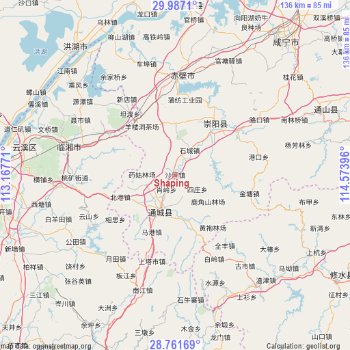
Shaping GPS coordinates[2]
29° 22' 34.464" North, 113° 52' 14.988" East
| Map corner | latitude | longitude |
|---|---|---|
| Upper-left | 29.9871°, | 113.16771° |
| Center: | 29.37624°, | 113.87083° |
| Lower-right: | 28.76169°, | 114.57396° |
| Map W x H: | 136.3×136.3 km | = 84.7×84.7mi |
| max Lat: | 53.31946° ⇑61% North |
| Shaping: | 29.37624° |
| min Lat: | ⇓39% South 18.22056° |
| min Long | Shaping | max Long |
| 75.07348° | 113.87083° | 134.28917° |
| W 47.9%⇐ | ⇒52.1% E |
Elevation
Elevation of Shaping is 86 m = 282 ft, and this is 398.8 m = 1308 ft below average elevation for this country.
| Max E: |
5622 m = 18445 ft | 62.3% |
| Avg. | 484.8 m = 1591 ft | |
| Shaping | 86 m = 282 ft | |
Min E: |
-3 m = -10 ft | 37.7% |
See also: China elevation on elevation.city.
Geographical zone
Shaping is located in North temperate zone (between Tropic of Cancer and the Arctic Circle). Distance of this Northern Tropic circle is 660.4 km =410.4 mi to South.| Distance of | km | miles | from Shaping |
|---|---|---|---|
| North Pole | 6740.7 | 4188.5 | to North |
| Arctic Circle | 4134.8 | 2569.2 | to North |
| Tropic Cancer | 660.4 | 410.4 | to South |
| Equator | 3266.3 | 2029.6 | to South |


Nearby cities:
15 places around Shaping: (largest is in red/bold)
• Beigang
23.1 km =14.4 mi,  248°
248°
• Daping
18.3 km =11.4 mi, 253°
• Gaojian
22 km =13.7 mi,  119°
119°
• Guandao
17.9 km =11.1 mi,  170°
170°
• Guihuaquan
20.3 km =12.6 mi,  0°
0°
• Juanshui
8.3 km =5.2 mi, 169°
• Qingshan
16 km =9.9 mi,  64°
64°
• Shadui
8.3 km =5.2 mi,  161°
161°
• Shicheng
11.3 km =7 mi,  28°
28°
• Shinan
18.7 km =11.6 mi,  234°
234°
• Sizhuang
9.5 km =5.9 mi,  127°
127°
• Tanghu
21.1 km =13.1 mi,  149°
149°
• Wuli
19.4 km =12.1 mi,  206°
206°
• Xiaoling
7 km =4.3 mi, 245°
• Yangloudong
22.1 km =13.7 mi,  326°
326°
Sources, notices
• [Note1] Compared only with cities in China existing in our database
• [Src1] Map data: © OpenStreetMap contributors (CC-BY-SA)
• [Src2] Other city data from geonames.org with taken over terms of usage.
• [Src3] Geographical zone / Annual Mean Temperature by Robert A. Rohde @ Wikipedia
