Gangkou geodata
Gangkou (Hubei) is a seat of a fourth-order administrative division; located in China in Asia/Shanghai (GMT+8) time zone. In our database, there are 1268 cities with bigger population. Compared to other cities in China, 60.5% of cities are located further ↑North; 50.2% of cities are located further →East and 60.3% of cities have higher elevation than Gangkou. Note1


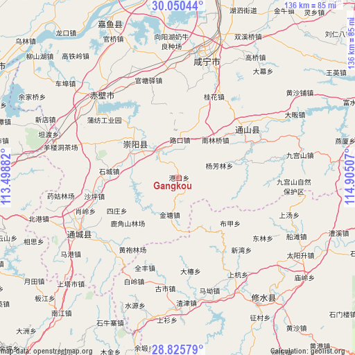
Gangkou GPS coordinates[2]
29° 26' 23.856" North, 114° 12' 6.984" East
| Map corner | latitude | longitude |
|---|---|---|
| Upper-left | 30.05044°, | 113.49882° |
| Center: | 29.43996°, | 114.20194° |
| Lower-right: | 28.82579°, | 114.90507° |
| Map W x H: | 136.2×136.2 km | = 84.6×84.6mi |
| max Lat: | 53.31946° ⇑60.5% North |
| Gangkou: | 29.43996° |
| min Lat: | ⇓39.5% South 18.22056° |
| min Long | Gangkou | max Long |
| 75.07348° | 114.20194° | 134.28917° |
| W 49.8%⇐ | ⇒50.2% E |
Elevation
Elevation of Gangkou is 97 m = 318 ft, and this is 387.8 m = 1272 ft below average elevation for this country.
| Max E: |
5622 m = 18445 ft | 60.3% |
| Avg. | 484.8 m = 1591 ft | |
| Gangkou | 97 m = 318 ft | |
Min E: |
-3 m = -10 ft | 39.7% |
See also: China elevation on elevation.city.
Geographical zone
Gangkou is located in North temperate zone (between Tropic of Cancer and the Arctic Circle). Distance of this Northern Tropic circle is 667.5 km =414.8 mi to South.| Distance of | km | miles | from Gangkou |
|---|---|---|---|
| North Pole | 6733.6 | 4184.1 | to North |
| Arctic Circle | 4127.8 | 2564.9 | to North |
| Tropic Cancer | 667.5 | 414.8 | to South |
| Equator | 3273.4 | 2034 | to South |


Nearby cities:
15 places around Gangkou: (largest is in red/bold)
• Baini
12.7 km =7.9 mi,  326°
326°
• Bujia
26.4 km =16.4 mi,  130°
130°
• Dalu
28.4 km =17.6 mi,  51°
51°
• Gangkou
23.9 km =14.9 mi,  148°
148°
• Gaojian
22.2 km =13.8 mi,  215°
215°
• Jintang
14.4 km =8.9 mi,  192°
192°
• Lukou
14.6 km =9.1 mi,  1°
1°
• Nanlinqiao
20.4 km =12.7 mi,  43°
43°
• Qingshan
17.7 km =11 mi,  269°
269°
• Shicheng
26.8 km =16.7 mi,  276°
276°
• Sizhuang
27.7 km =17.2 mi,  242°
242°
• Tiancheng
19.1 km =11.9 mi,  305°
305°
• Tongzhong
10.1 km =6.3 mi,  293°
293°
• Xiapu
26.7 km =16.6 mi,  71°
71°
• Yangfanglin
16.3 km =10.1 mi, 72°
Sources, notices
• [Note1] Compared only with cities in China existing in our database
• [Src1] Map data: © OpenStreetMap contributors (CC-BY-SA)
• [Src2] Other city data from geonames.org with taken over terms of usage.
• [Src3] Geographical zone / Annual Mean Temperature by Robert A. Rohde @ Wikipedia
