Tantou geodata
Tantou (Hunan) is a seat of a fourth-order administrative division; located in China in Asia/Shanghai (GMT+8) time zone. In our database, there are 1268 cities with bigger population. Compared to other cities in China, 77.5% of cities are located further ↑North; 66.5% of cities are located further →East and 67.2% of cities have lower elevation than Tantou. Note1


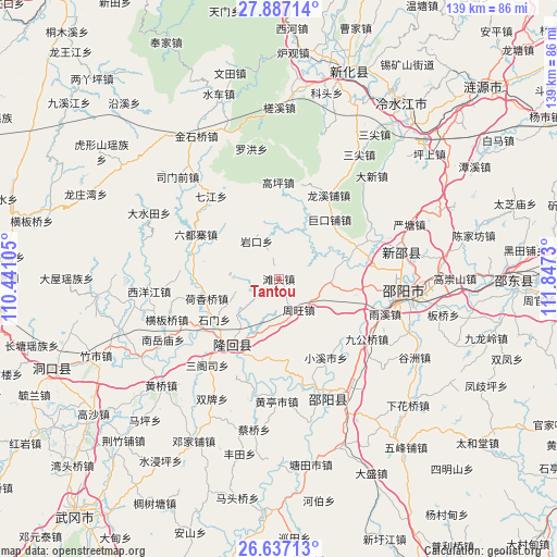
Tantou GPS coordinates[2]
27° 15' 50.004" North, 111° 8' 39.012" East
| Map corner | latitude | longitude |
|---|---|---|
| Upper-left | 27.88714°, | 110.44105° |
| Center: | 27.26389°, | 111.14417° |
| Lower-right: | 26.63713°, | 111.8473° |
| Map W x H: | 139×139 km | = 86.4×86.4mi |
| max Lat: | 53.31946° ⇑77.5% North |
| Tantou: | 27.26389° |
| min Lat: | ⇓22.5% South 18.22056° |
| min Long | Tantou | max Long |
| 75.07348° | 111.14417° | 134.28917° |
| W 33.5%⇐ | ⇒66.5% E |
Elevation
Elevation of Tantou is 362 m = 1188 ft, and this is 122.8 m = 403 ft below average elevation for this country.
| Max E: |
5622 m = 18445 ft | 32.8% |
| Avg. | 484.8 m = 1591 ft | |
| Tantou | 362 m = 1188 ft | |
Min E: |
-3 m = -10 ft | 67.2% |
See also: China elevation on elevation.city.
Geographical zone
Tantou is located in North temperate zone (between Tropic of Cancer and the Arctic Circle). Distance of this Northern Tropic circle is 425.5 km =264.4 mi to South.| Distance of | km | miles | from Tantou |
|---|---|---|---|
| North Pole | 6975.6 | 4334.4 | to North |
| Arctic Circle | 4369.7 | 2715.2 | to North |
| Tropic Cancer | 425.5 | 264.4 | to South |
| Equator | 3031.5 | 1883.7 | to South |


Nearby cities:
15 places around Tantou: (largest is in red/bold)
• Beishan
20.9 km =13 mi,  195°
195°
• Gaoping
24 km =14.9 mi,  359°
359°
• Hengbanqiao
29.4 km =18.3 mi,  249°
249°
• Hetian
19.4 km =12.1 mi,  298°
298°
• Hexiangqiao
18.5 km =11.5 mi, 254°
• Liuduzhai
23.6 km =14.7 mi, 298°
• Niangxi
28.9 km =18 mi,  80°
80°
• Qijiang
26.7 km =16.6 mi,  320°
320°
• Sangesi
28.8 km =17.9 mi,  220°
220°
• Shanjie
24.1 km =15 mi,  210°
210°
• Shimen
12 km =7.5 mi, 249°
• Taohong
23.4 km =14.5 mi, 219°
• Yankou
10.9 km =6.8 mi,  329°
329°
• Yushanpu
13 km =8.1 mi,  193°
193°
• Zhouwang
9.2 km =5.7 mi,  147°
147°
Sources, notices
• [Note1] Compared only with cities in China existing in our database
• [Src1] Map data: © OpenStreetMap contributors (CC-BY-SA)
• [Src2] Other city data from geonames.org with taken over terms of usage.
• [Src3] Geographical zone / Annual Mean Temperature by Robert A. Rohde @ Wikipedia
