Beishan geodata
Beishan (Hunan) is a seat of a fourth-order administrative division; located in China in Asia/Shanghai (GMT+8) time zone. In our database, there are 1268 cities with bigger population. Compared to other cities in China, 78.3% of cities are located further ↑North; 66.7% of cities are located further →East and 63.6% of cities have lower elevation than Beishan. Note1


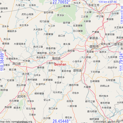
Beishan GPS coordinates[2]
27° 4' 56.1" North, 111° 5' 17.196" East
| Map corner | latitude | longitude |
|---|---|---|
| Upper-left | 27.70652°, | 110.38499° |
| Center: | 27.08225°, | 111.08811° |
| Lower-right: | 26.45448°, | 111.79124° |
| Map W x H: | 139.2×139.2 km | = 86.5×86.5mi |
| max Lat: | 53.31946° ⇑78.3% North |
| Beishan: | 27.08225° |
| min Lat: | ⇓21.7% South 18.22056° |
| min Long | Beishan | max Long |
| 75.07348° | 111.08811° | 134.28917° |
| W 33.3%⇐ | ⇒66.7% E |
Elevation
Elevation of Beishan is 306 m = 1004 ft, and this is 178.8 m = 587 ft below average elevation for this country.
| Max E: |
5622 m = 18445 ft | 36.4% |
| Avg. | 484.8 m = 1591 ft | |
| Beishan | 306 m = 1004 ft | |
Min E: |
-3 m = -10 ft | 63.6% |
See also: China elevation on elevation.city.
Geographical zone
Beishan is located in North temperate zone (between Tropic of Cancer and the Arctic Circle). Distance of this Northern Tropic circle is 405.3 km =251.8 mi to South.| Distance of | km | miles | from Beishan |
|---|---|---|---|
| North Pole | 6995.8 | 4347 | to North |
| Arctic Circle | 4389.9 | 2727.8 | to North |
| Tropic Cancer | 405.3 | 251.8 | to South |
| Equator | 3011.3 | 1871.1 | to South |


Nearby cities:
15 places around Beishan: (largest is in red/bold)
• Dengjiapu
25.9 km =16.1 mi,  220°
220°
• Hengbanqiao
24.2 km =15 mi,  294°
294°
• Hexiangqiao
19.7 km =12.2 mi,  321°
321°
• Huangqiao
25.4 km =15.8 mi,  254°
254°
• Nanyuemiao
23.9 km =14.9 mi,  282°
282°
• Sangesi
13.3 km =8.3 mi,  262°
262°
• Shanjie
6.8 km =4.2 mi,  265°
265°
• Shijiang
29.2 km =18.1 mi, 269°
• Shimen
17.1 km =10.6 mi,  340°
340°
• Tangdukou
19.9 km =12.4 mi,  130°
130°
• Tantou
20.9 km =13 mi,  15°
15°
• Taohong
9.5 km =5.9 mi, 282°
• Xiyangjiang
28.3 km =17.6 mi,  295°
295°
• Yushanpu
8 km =5 mi, 18°
• Zhouwang
16.3 km =10.1 mi,  40°
40°
Sources, notices
• [Note1] Compared only with cities in China existing in our database
• [Src1] Map data: © OpenStreetMap contributors (CC-BY-SA)
• [Src2] Other city data from geonames.org with taken over terms of usage.
• [Src3] Geographical zone / Annual Mean Temperature by Robert A. Rohde @ Wikipedia
