Taiping geodata
Taiping (Sichuan) is a populated place; located in China in Asia/Shanghai (GMT+8) time zone. With population of 3,000 people, there are 949 cities with bigger population in this country. Compared to other cities in China, 73% of cities are located further ↑North; 86.8% of cities are located further →East and 65.1% of cities have lower elevation than Taiping. Note1


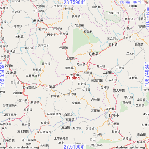
Taiping GPS coordinates[2]
28° 8' 26.988" North, 106° 2' 15.756" East
| Map corner | latitude | longitude |
|---|---|---|
| Upper-left | 28.75904°, | 105.33459° |
| Center: | 28.14083°, | 106.03771° |
| Lower-right: | 27.51904°, | 106.74084° |
| Map W x H: | 137.9×137.9 km | = 85.7×85.7mi |
| max Lat: | 53.31946° ⇑73% North |
| Taiping: | 28.14083° |
| min Lat: | ⇓27% South 18.22056° |
| min Long | Taiping | max Long |
| 75.07348° | 106.03771° | 134.28917° |
| W 13.2%⇐ | ⇒86.8% E |
Elevation
Elevation of Taiping is 327 m = 1073 ft, and this is 157.8 m = 518 ft below average elevation for this country.
| Max E: |
5622 m = 18445 ft | 34.9% |
| Avg. | 484.8 m = 1591 ft | |
| Taiping | 327 m = 1073 ft | |
Min E: |
-3 m = -10 ft | 65.1% |
See also: China elevation on elevation.city.
Geographical zone
Taiping is located in North temperate zone (between Tropic of Cancer and the Arctic Circle). Distance of this Northern Tropic circle is 523 km =325 mi to South.| Distance of | km | miles | from Taiping |
|---|---|---|---|
| North Pole | 6878.1 | 4273.9 | to North |
| Arctic Circle | 4272.2 | 2654.6 | to North |
| Tropic Cancer | 523 | 325 | to South |
| Equator | 3129 | 1944.3 | to South |


Nearby cities:
15 places around Taiping: (largest is in red/bold)
• Daba
40.7 km =25.3 mi,  109°
109°
• Dacun
17.2 km =10.7 mi,  141°
141°
• Donghuang
27.6 km =17.1 mi,  39°
39°
• Guandu
48 km =29.8 mi,  7°
7°
• Gulin
24.8 km =15.4 mi,  243°
243°
• Hema
30.7 km =19.1 mi, 111°
• Liangcunchang
48 km =29.8 mi,  52°
52°
• Sangmu
24.1 km =15 mi,  69°
69°
• Sanhe
31.5 km =19.6 mi,  104°
104°
• Sanyuanchang
26.6 km =16.5 mi,  26°
26°
• Shatan
22.7 km =14.1 mi, 98°
• Tongmin
6.4 km =4 mi,  320°
320°
• Tucheng
17.4 km =10.8 mi,  345°
345°
• Yong’an
38.6 km =24 mi,  79°
79°
• Yuanhou
23 km =14.3 mi,  344°
344°
Sources, notices
• [Note1] Compared only with cities in China existing in our database
• [Src1] Map data: © OpenStreetMap contributors (CC-BY-SA)
• [Src2] Other city data from geonames.org with taken over terms of usage.
• [Src3] Geographical zone / Annual Mean Temperature by Robert A. Rohde @ Wikipedia
