Hema geodata
Hema (Guizhou) is a seat of a fourth-order administrative division; located in China in Asia/Shanghai (GMT+8) time zone. In our database, there are 1268 cities with bigger population. Compared to other cities in China, 73.8% of cities are located further ↑North; 85.7% of cities are located further →East and 72.3% of cities have lower elevation than Hema. Note1


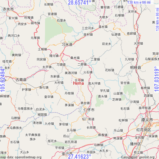
Hema GPS coordinates[2]
28° 2' 18.996" North, 106° 19' 41.016" East
| Map corner | latitude | longitude |
|---|---|---|
| Upper-left | 28.65741°, | 105.62494° |
| Center: | 28.03861°, | 106.32806° |
| Lower-right: | 27.41623°, | 107.03119° |
| Map W x H: | 138×138 km | = 85.7×85.7mi |
| max Lat: | 53.31946° ⇑73.8% North |
| Hema: | 28.03861° |
| min Lat: | ⇓26.2% South 18.22056° |
| min Long | Hema | max Long |
| 75.07348° | 106.32806° | 134.28917° |
| W 14.3%⇐ | ⇒85.7% E |
Elevation
Elevation of Hema is 460 m = 1509 ft, and this is 24.8 m = 81 ft below average elevation for this country.
| Max E: |
5622 m = 18445 ft | 27.7% |
| Avg. | 484.8 m = 1591 ft | |
| Hema | 460 m = 1509 ft | |
Min E: |
-3 m = -10 ft | 72.3% |
See also: China elevation on elevation.city.
Geographical zone
Hema is located in North temperate zone (between Tropic of Cancer and the Arctic Circle). Distance of this Northern Tropic circle is 511.7 km =318 mi to South.| Distance of | km | miles | from Hema |
|---|---|---|---|
| North Pole | 6889.5 | 4280.9 | to North |
| Arctic Circle | 4283.6 | 2661.7 | to North |
| Tropic Cancer | 511.7 | 318 | to South |
| Equator | 3117.6 | 1937.2 | to South |


Nearby cities:
15 places around Hema: (largest is in red/bold)
• Daba
10.1 km =6.3 mi,  104°
104°
• Dacun
17.8 km =11.1 mi,  263°
263°
• Donghuang
34.5 km =21.4 mi,  341°
341°
• Guancang
37.9 km =23.5 mi,  90°
90°
• Guandian
39.7 km =24.7 mi,  44°
44°
• Huaqiu
28.3 km =17.6 mi,  72°
72°
• Liangcunchang
42 km =26.1 mi,  12°
12°
• Renhuai
28.4 km =17.6 mi,  165°
165°
• Sangmu
20.5 km =12.7 mi, 343°
• Sanhe
3.9 km =2.4 mi,  30°
30°
• Sanyuanchang
38.8 km =24.1 mi,  334°
334°
• Shatan
9.9 km =6.2 mi,  322°
322°
• Taiping
30.7 km =19.1 mi,  291°
291°
• Tongmin
36.4 km =22.6 mi,  296°
296°
• Yong’an
20.6 km =12.8 mi, 27°
Sources, notices
• [Note1] Compared only with cities in China existing in our database
• [Src1] Map data: © OpenStreetMap contributors (CC-BY-SA)
• [Src2] Other city data from geonames.org with taken over terms of usage.
• [Src3] Geographical zone / Annual Mean Temperature by Robert A. Rohde @ Wikipedia
