Donghuang geodata
Donghuang (Guizhou) is a seat of a third-order administrative division; located in China in Asia/Shanghai (GMT+8) time zone. In our database, there are 1268 cities with bigger population. Compared to other cities in China, 71.2% of cities are located further ↑North; 86.1% of cities are located further →East and 88.3% of cities have lower elevation than Donghuang. Note1


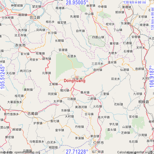
Donghuang GPS coordinates[2]
28° 19' 58.692" North, 106° 12' 56.052" East
| Map corner | latitude | longitude |
|---|---|---|
| Upper-left | 28.95005°, | 105.51245° |
| Center: | 28.33297°, | 106.21557° |
| Lower-right: | 27.71228°, | 106.9187° |
| Map W x H: | 137.6×137.6 km | = 85.5×85.5mi |
| max Lat: | 53.31946° ⇑71.2% North |
| Donghuang: | 28.33297° |
| min Lat: | ⇓28.8% South 18.22056° |
| min Long | Donghuang | max Long |
| 75.07348° | 106.21557° | 134.28917° |
| W 13.9%⇐ | ⇒86.1% E |
Elevation
Elevation of Donghuang is 1208 m = 3963 ft, and this is 723.2 m = 2373 ft above average elevation for this country.
| Max E: |
5622 m = 18445 ft | 11.7% |
| Donghuang | 1208 m 3963 ft | |
| Avg. | 484.8 m = 1591 ft | |
Min E: |
-3 m = -10 ft | 88.3% |
See also: China elevation on elevation.city.
Geographical zone
Donghuang is located in North temperate zone (between Tropic of Cancer and the Arctic Circle). Distance of this Northern Tropic circle is 544.4 km =338.3 mi to South.| Distance of | km | miles | from Donghuang |
|---|---|---|---|
| North Pole | 6856.7 | 4260.6 | to North |
| Arctic Circle | 4250.8 | 2641.3 | to North |
| Tropic Cancer | 544.4 | 338.3 | to South |
| Equator | 3150.3 | 1957.5 | to South |


Nearby cities:
15 places around Donghuang: (largest is in red/bold)
• Changqi
35 km =21.7 mi,  335°
335°
• Guandu
28.4 km =17.6 mi, 337°
• Hema
34.5 km =21.4 mi,  161°
161°
• Liangcunchang
22 km =13.7 mi,  68°
68°
• Sanchahe
27.5 km =17.1 mi,  49°
49°
• Sangmu
14.1 km =8.8 mi, 158°
• Sanhe
32.1 km =19.9 mi, 156°
• Sanyuanchang
5.9 km =3.7 mi,  293°
293°
• Shatan
25.4 km =15.8 mi,  168°
168°
• Taiping
27.6 km =17.1 mi,  219°
219°
• Tongmin
27.1 km =16.8 mi,  232°
232°
• Tucheng
22.2 km =13.8 mi,  258°
258°
• Wenshui
33.1 km =20.6 mi, 66°
• Yong’an
25.1 km =15.6 mi,  125°
125°
• Yuanhou
23.5 km =14.6 mi,  272°
272°
Sources, notices
• [Note1] Compared only with cities in China existing in our database
• [Src1] Map data: © OpenStreetMap contributors (CC-BY-SA)
• [Src2] Other city data from geonames.org with taken over terms of usage.
• [Src3] Geographical zone / Annual Mean Temperature by Robert A. Rohde @ Wikipedia
