Sanhe geodata
Sanhe (Guizhou) is a seat of a fourth-order administrative division; located in China in Asia/Shanghai (GMT+8) time zone. With population of 974 people, there are 1186 cities with bigger population in this country. Compared to other cities in China, 73.5% of cities are located further ↑North; 85.6% of cities are located further →East and 85.3% of cities have lower elevation than Sanhe. Note1


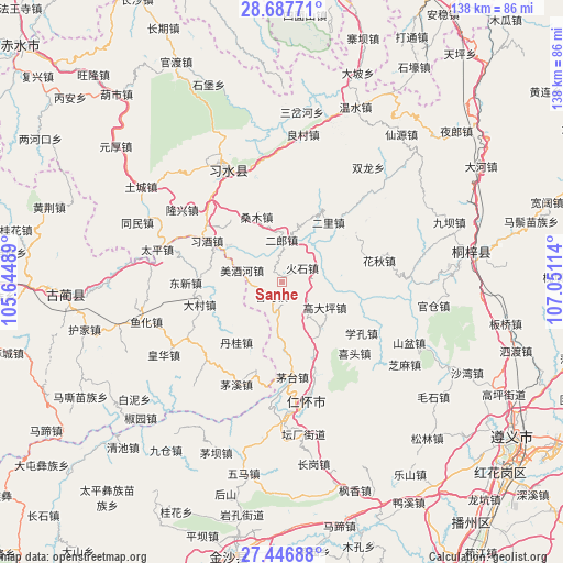
Sanhe GPS coordinates[2]
28° 4' 8.724" North, 106° 20' 52.836" East
| Map corner | latitude | longitude |
|---|---|---|
| Upper-left | 28.68771°, | 105.64489° |
| Center: | 28.06909°, | 106.34801° |
| Lower-right: | 27.44688°, | 107.05114° |
| Map W x H: | 138×138 km | = 85.7×85.7mi |
| max Lat: | 53.31946° ⇑73.5% North |
| Sanhe: | 28.06909° |
| min Lat: | ⇓26.5% South 18.22056° |
| min Long | Sanhe | max Long |
| 75.07348° | 106.34801° | 134.28917° |
| W 14.4%⇐ | ⇒85.6% E |
Elevation
Elevation of Sanhe is 999 m = 3278 ft, and this is 514.2 m = 1687 ft above average elevation for this country.
| Max E: |
5622 m = 18445 ft | 14.7% |
| Sanhe | 999 m 3278 ft | |
| Avg. | 484.8 m = 1591 ft | |
Min E: |
-3 m = -10 ft | 85.3% |
See also: China elevation on elevation.city.
Geographical zone
Sanhe is located in North temperate zone (between Tropic of Cancer and the Arctic Circle). Distance of this Northern Tropic circle is 515.1 km =320.1 mi to South.| Distance of | km | miles | from Sanhe |
|---|---|---|---|
| North Pole | 6886.1 | 4278.8 | to North |
| Arctic Circle | 4280.2 | 2659.6 | to North |
| Tropic Cancer | 515.1 | 320.1 | to South |
| Equator | 3121 | 1939.3 | to South |


Nearby cities:
15 places around Sanhe: (largest is in red/bold)
• Daba
9.8 km =6.1 mi,  126°
126°
• Dacun
20.4 km =12.7 mi,  254°
254°
• Donghuang
32.1 km =19.9 mi,  336°
336°
• Guancang
36.1 km =22.4 mi,  95°
95°
• Guandian
35.9 km =22.3 mi,  45°
45°
• Hema
3.9 km =2.4 mi,  210°
210°
• Huaqiu
25.5 km =15.8 mi,  78°
78°
• Liangcunchang
38.3 km =23.8 mi,  11°
11°
• Renhuai
31.3 km =19.4 mi,  170°
170°
• Sangmu
18 km =11.2 mi,  334°
334°
• Sanyuanchang
36.7 km =22.8 mi, 329°
• Shatan
9.2 km =5.7 mi,  299°
299°
• Taiping
31.5 km =19.6 mi,  284°
284°
• Tongmin
36.9 km =22.9 mi,  290°
290°
• Yong’an
16.7 km =10.4 mi,  26°
26°
Sources, notices
• [Note1] Compared only with cities in China existing in our database
• [Src1] Map data: © OpenStreetMap contributors (CC-BY-SA)
• [Src2] Other city data from geonames.org with taken over terms of usage.
• [Src3] Geographical zone / Annual Mean Temperature by Robert A. Rohde @ Wikipedia
