Songhe geodata
Songhe (Hubei) is a seat of a fourth-order administrative division; located in China in Asia/Shanghai (GMT+8) time zone. In our database, there are 1268 cities with bigger population. Compared to other cities in China, 56.2% of cities are located further ↓South; 55.7% of cities are located further →East and 65.6% of cities have higher elevation than Songhe. Note1


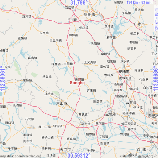
Songhe GPS coordinates[2]
31° 11' 47.292" North, 113° 17' 1.428" East
| Map corner | latitude | longitude |
|---|---|---|
| Upper-left | 31.796°, | 112.58061° |
| Center: | 31.19647°, | 113.28373° |
| Lower-right: | 30.59312°, | 113.98686° |
| Map W x H: | 133.7×133.7 km | = 83.1×83.1mi |
| max Lat: | 53.31946° ⇑43.8% North |
| Songhe: | 31.19647° |
| min Lat: | ⇓56.2% South 18.22056° |
| min Long | Songhe | max Long |
| 75.07348° | 113.28373° | 134.28917° |
| W 44.3%⇐ | ⇒55.7% E |
Elevation
Elevation of Songhe is 70 m = 230 ft, and this is 414.8 m = 1361 ft below average elevation for this country.
| Max E: |
5622 m = 18445 ft | 65.6% |
| Avg. | 484.8 m = 1591 ft | |
| Songhe | 70 m = 230 ft | |
Min E: |
-3 m = -10 ft | 34.4% |
See also: China elevation on elevation.city.
Geographical zone
Songhe is located in North temperate zone (between Tropic of Cancer and the Arctic Circle). Distance of this Northern Tropic circle is 862.8 km =536.1 mi to South.| Distance of | km | miles | from Songhe |
|---|---|---|---|
| North Pole | 6538.3 | 4062.7 | to North |
| Arctic Circle | 3932.5 | 2443.5 | to North |
| Tropic Cancer | 862.8 | 536.1 | to South |
| Equator | 3468.7 | 2155.3 | to South |


Nearby cities:
15 places around Songhe: (largest is in red/bold)
• Caowu
25.7 km =16 mi,  167°
167°
• Leigong
24.2 km =15 mi,  63°
63°
• Luodian
13.9 km =8.6 mi,  132°
132°
• Lülin
23.6 km =14.7 mi,  303°
303°
• Muzi
25.3 km =15.7 mi,  81°
81°
• Pingba
13.6 km =8.5 mi,  13°
13°
• Sanyang
16.3 km =10.1 mi,  324°
324°
• Sunqiao
28.4 km =17.6 mi,  244°
244°
• Tangdi
29.2 km =18.1 mi, 80°
• Tiandian
24.3 km =15.1 mi,  139°
139°
• Wangyi Zhendian
17.5 km =10.9 mi,  31°
31°
• Wufu
29.9 km =18.6 mi,  183°
183°
• Xinshi
21.5 km =13.4 mi,  219°
219°
• Yangji
27.6 km =17.1 mi,  275°
275°
• Yongxing
26.3 km =16.3 mi,  191°
191°
Sources, notices
• [Note1] Compared only with cities in China existing in our database
• [Src1] Map data: © OpenStreetMap contributors (CC-BY-SA)
• [Src2] Other city data from geonames.org with taken over terms of usage.
• [Src3] Geographical zone / Annual Mean Temperature by Robert A. Rohde @ Wikipedia
