Si’an geodata
Si’an (Zhejiang) is a seat of a fourth-order administrative division; located in China in Asia/Shanghai (GMT+8) time zone. In our database, there are 1268 cities with bigger population. Compared to other cities in China, 53.8% of cities are located further ↓South; 79.7% of cities are located further ←West and 84.9% of cities have higher elevation than Si’an. Note1


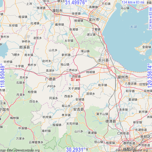
Si’an GPS coordinates[2]
30° 53' 53.988" North, 119° 39' 12.996" East
| Map corner | latitude | longitude |
|---|---|---|
| Upper-left | 31.49976°, | 118.95049° |
| Center: | 30.89833°, | 119.65361° |
| Lower-right: | 30.2931°, | 120.35674° |
| Map W x H: | 134.2×134.2 km | = 83.4×83.4mi |
| max Lat: | 53.31946° ⇑46.2% North |
| Si’an: | 30.89833° |
| min Lat: | ⇓53.8% South 18.22056° |
| min Long | Si’an | max Long |
| 75.07348° | 119.65361° | 134.28917° |
| W 79.7%⇐ | ⇒20.3% E |
Elevation
Elevation of Si’an is 16 m = 52 ft, and this is 468.8 m = 1538 ft below average elevation for this country.
| Max E: |
5622 m = 18445 ft | 84.9% |
| Avg. | 484.8 m = 1591 ft | |
| Si’an | 16 m = 52 ft | |
Min E: |
-3 m = -10 ft | 15.1% |
See also: China elevation on elevation.city.
Geographical zone
Si’an is located in North temperate zone (between Tropic of Cancer and the Arctic Circle). Distance of this Northern Tropic circle is 829.7 km =515.6 mi to South.| Distance of | km | miles | from Si’an |
|---|---|---|---|
| North Pole | 6571.5 | 4083.3 | to North |
| Arctic Circle | 3965.6 | 2464.1 | to North |
| Tropic Cancer | 829.7 | 515.6 | to South |
| Equator | 3435.6 | 2134.8 | to South |


Nearby cities:
15 places around Si’an: (largest is in red/bold)
• Bengkouling
23.7 km =14.7 mi,  248°
248°
• Cishangang
13.8 km =8.6 mi,  275°
275°
• Dongting
13.1 km =8.1 mi,  257°
257°
• Erjieling
6.7 km =4.2 mi,  325°
325°
• Gaoyu
9.6 km =6 mi,  206°
206°
• Hongxingqiao
20.7 km =12.9 mi,  82°
82°
• Huaikan
19.3 km =12 mi,  7°
7°
• Kuntong
19.9 km =12.4 mi,  139°
139°
• Lincheng
13.3 km =8.3 mi,  72°
72°
• Liudong
19.6 km =12.2 mi,  319°
319°
• Taozhou
23.4 km =14.5 mi,  272°
272°
• Xiaopu
22.4 km =13.9 mi,  49°
49°
• Ximu
18.6 km =11.6 mi,  200°
200°
• Xinhang
21.1 km =13.1 mi,  335°
335°
• Zhangwu
16.8 km =10.4 mi,  218°
218°
Sources, notices
• [Note1] Compared only with cities in China existing in our database
• [Src1] Map data: © OpenStreetMap contributors (CC-BY-SA)
• [Src2] Other city data from geonames.org with taken over terms of usage.
• [Src3] Geographical zone / Annual Mean Temperature by Robert A. Rohde @ Wikipedia
