Longping geodata
Longping (Hubei) is a seat of a fourth-order administrative division; located in China in Asia/Shanghai (GMT+8) time zone. In our database, there are 1268 cities with bigger population. Compared to other cities in China, 55.4% of cities are located further ↑North; 58.1% of cities are located further ←West and 82.1% of cities have higher elevation than Longping. Note1


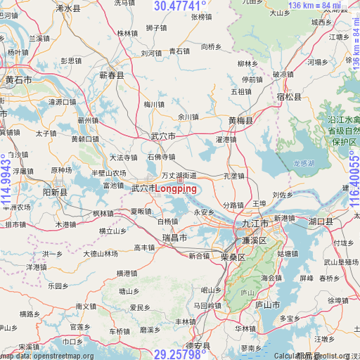
Longping GPS coordinates[2]
29° 52' 10.416" North, 115° 41' 50.712" East
| Map corner | latitude | longitude |
|---|---|---|
| Upper-left | 30.47741°, | 114.9943° |
| Center: | 29.86956°, | 115.69742° |
| Lower-right: | 29.25798°, | 116.40055° |
| Map W x H: | 135.6×135.6 km | = 84.3×84.3mi |
| max Lat: | 53.31946° ⇑55.4% North |
| Longping: | 29.86956° |
| min Lat: | ⇓44.6% South 18.22056° |
| min Long | Longping | max Long |
| 75.07348° | 115.69742° | 134.28917° |
| W 58.1%⇐ | ⇒41.9% E |
Elevation
Elevation of Longping is 22 m = 72 ft, and this is 462.8 m = 1518 ft below average elevation for this country.
| Max E: |
5622 m = 18445 ft | 82.1% |
| Avg. | 484.8 m = 1591 ft | |
| Longping | 22 m = 72 ft | |
Min E: |
-3 m = -10 ft | 17.9% |
See also: China elevation on elevation.city.
Geographical zone
Longping is located in North temperate zone (between Tropic of Cancer and the Arctic Circle). Distance of this Northern Tropic circle is 715.3 km =444.5 mi to South.| Distance of | km | miles | from Longping |
|---|---|---|---|
| North Pole | 6685.9 | 4154.4 | to North |
| Arctic Circle | 4080 | 2535.2 | to North |
| Tropic Cancer | 715.3 | 444.5 | to South |
| Equator | 3321.2 | 2063.7 | to South |


Nearby cities:
15 places around Longping: (largest is in red/bold)
• Baiyang
15.8 km =9.8 mi,  197°
197°
• Caishan
8.8 km =5.5 mi,  79°
79°
• Chengzi
3.7 km =2.3 mi,  193°
193°
• Dajin
16.5 km =10.3 mi,  330°
330°
• Gangkoujie
18 km =11.2 mi,  153°
153°
• Huaqiao
16 km =9.9 mi,  6°
6°
• Konglong
19.9 km =12.4 mi, 84°
• Matou
12.3 km =7.6 mi,  249°
249°
• Shifosi
11.6 km =7.2 mi,  322°
322°
• Wujiao
13.3 km =8.3 mi,  212°
212°
• Wuxue
14.1 km =8.8 mi,  261°
261°
• Xiafan
18.8 km =11.7 mi,  232°
232°
• Xinkai
12.6 km =7.8 mi,  120°
120°
• Yong’an
14.6 km =9.1 mi,  142°
142°
• Zhanghekou
14.8 km =9.2 mi,  19°
19°
Sources, notices
• [Note1] Compared only with cities in China existing in our database
• [Src1] Map data: © OpenStreetMap contributors (CC-BY-SA)
• [Src2] Other city data from geonames.org with taken over terms of usage.
• [Src3] Geographical zone / Annual Mean Temperature by Robert A. Rohde @ Wikipedia
