Guankou geodata
Guankou (Hunan) is a seat of a third-order administrative division; located in China in Asia/Shanghai (GMT+8) time zone. With population of 1,380,000 people, there are 50 cities with bigger population in this country. Compared to other cities in China, 72.8% of cities are located further ↑North; 53.5% of cities are located further →East and 63.7% of cities have higher elevation than Guankou. Note1


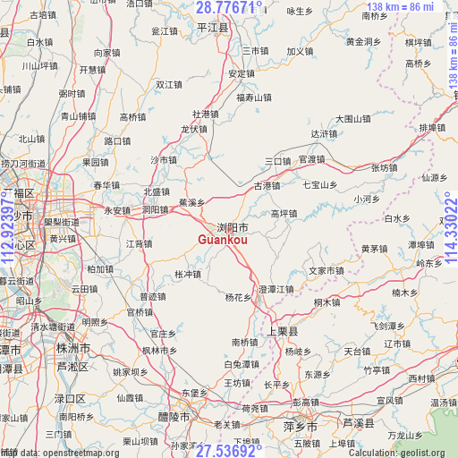
Guankou GPS coordinates[2]
28° 9' 30.996" North, 113° 37' 37.524" East
| Map corner | latitude | longitude |
|---|---|---|
| Upper-left | 28.77671°, | 112.92397° |
| Center: | 28.15861°, | 113.62709° |
| Lower-right: | 27.53692°, | 114.33022° |
| Map W x H: | 137.9×137.9 km | = 85.7×85.7mi |
| max Lat: | 53.31946° ⇑72.8% North |
| Guankou: | 28.15861° |
| min Lat: | ⇓27.2% South 18.22056° |
| min Long | Guankou | max Long |
| 75.07348° | 113.62709° | 134.28917° |
| W 46.5%⇐ | ⇒53.5% E |
Elevation
Elevation of Guankou is 79 m = 259 ft, and this is 405.8 m = 1331 ft below average elevation for this country.
| Max E: |
5622 m = 18445 ft | 63.7% |
| Avg. | 484.8 m = 1591 ft | |
| Guankou | 79 m = 259 ft | |
Min E: |
-3 m = -10 ft | 36.3% |
See also: Guankou elevation on elevation.city.
Geographical zone
Guankou is located in North temperate zone (between Tropic of Cancer and the Arctic Circle). Distance of this Northern Tropic circle is 525 km =326.2 mi to South.| Distance of | km | miles | from Guankou |
|---|---|---|---|
| North Pole | 6876.1 | 4272.6 | to North |
| Arctic Circle | 4270.2 | 2653.4 | to North |
| Tropic Cancer | 525 | 326.2 | to South |
| Equator | 3130.9 | 1945.5 | to South |


Nearby cities:
15 places around Guankou: (largest is in red/bold)
• Baisha
56.7 km =35.2 mi,  52°
52°
• Baishui
50.5 km =31.4 mi,  86°
86°
• Cihua
42.5 km =26.4 mi,  112°
112°
• Daweishan
50.3 km =31.3 mi, 47°
• Feijiantan
56 km =34.8 mi,  121°
121°
• Heshikou
42.8 km =26.6 mi,  80°
80°
• Huangmao
44.1 km =27.4 mi,  97°
97°
• Nanmu
56.2 km =34.9 mi, 109°
• Shangli
35.2 km =21.9 mi,  152°
152°
• Tiantai
53.1 km =33 mi,  133°
133°
• Tiantaishan
47.6 km =29.6 mi, 129°
• Xingsha
53.6 km =33.3 mi,  279°
279°
• Xishan
56.1 km =34.9 mi,  192°
192°
• Zhangfang
50.2 km =31.2 mi,  68°
68°
• Zhutan
53.6 km =33.3 mi, 102°
Sources, notices
• [Note1] Compared only with cities in China existing in our database
• [Src1] Map data: © OpenStreetMap contributors (CC-BY-SA)
• [Src2] Other city data from geonames.org with taken over terms of usage.
• [Src3] Geographical zone / Annual Mean Temperature by Robert A. Rohde @ Wikipedia
