Pingba geodata
Pingba (Hubei) is a seat of a fourth-order administrative division; located in China in Asia/Shanghai (GMT+8) time zone. In our database, there are 1268 cities with bigger population. Compared to other cities in China, 57.2% of cities are located further ↓South; 55.5% of cities are located further →East and 63.5% of cities have higher elevation than Pingba. Note1


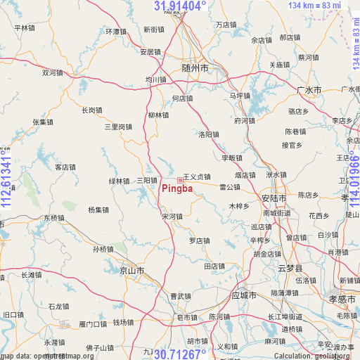
Pingba GPS coordinates[2]
31° 18' 54.972" North, 113° 18' 59.508" East
| Map corner | latitude | longitude |
|---|---|---|
| Upper-left | 31.91404°, | 112.61341° |
| Center: | 31.31527°, | 113.31653° |
| Lower-right: | 30.71267°, | 114.01966° |
| Map W x H: | 133.6×133.6 km | = 83×83mi |
| max Lat: | 53.31946° ⇑42.8% North |
| Pingba: | 31.31527° |
| min Lat: | ⇓57.2% South 18.22056° |
| min Long | Pingba | max Long |
| 75.07348° | 113.31653° | 134.28917° |
| W 44.5%⇐ | ⇒55.5% E |
Elevation
Elevation of Pingba is 80 m = 262 ft, and this is 404.8 m = 1328 ft below average elevation for this country.
| Max E: |
5622 m = 18445 ft | 63.5% |
| Avg. | 484.8 m = 1591 ft | |
| Pingba | 80 m = 262 ft | |
Min E: |
-3 m = -10 ft | 36.5% |
See also: China elevation on elevation.city.
Geographical zone
Pingba is located in North temperate zone (between Tropic of Cancer and the Arctic Circle). Distance of this Northern Tropic circle is 876 km =544.3 mi to South.| Distance of | km | miles | from Pingba |
|---|---|---|---|
| North Pole | 6525.1 | 4054.5 | to North |
| Arctic Circle | 3919.2 | 2435.3 | to North |
| Tropic Cancer | 876 | 544.3 | to South |
| Equator | 3481.9 | 2163.6 | to South |


Nearby cities:
15 places around Pingba: (largest is in red/bold)
• Beifan
21 km =13 mi,  68°
68°
• Hedian
30.9 km =19.2 mi,  0°
0°
• Leigong
18.6 km =11.6 mi,  97°
97°
• Liulin
26.2 km =16.3 mi,  342°
342°
• Luodian
23.6 km =14.7 mi,  162°
162°
• Luoyang
20.3 km =12.6 mi,  30°
30°
• Lülin
22.8 km =14.2 mi,  269°
269°
• Muzi
23.9 km =14.9 mi,  113°
113°
• Pinglin
29.6 km =18.4 mi, 67°
• Sanligang
30.4 km =18.9 mi,  310°
310°
• Sanyang
12.5 km =7.8 mi, 270°
• Songhe
13.6 km =8.5 mi,  193°
193°
• Tangdi
27 km =16.8 mi, 108°
• Wangyi Zhendian
6.2 km =3.9 mi, 74°
• Yandian
23.8 km =14.8 mi,  84°
84°
Sources, notices
• [Note1] Compared only with cities in China existing in our database
• [Src1] Map data: © OpenStreetMap contributors (CC-BY-SA)
• [Src2] Other city data from geonames.org with taken over terms of usage.
• [Src3] Geographical zone / Annual Mean Temperature by Robert A. Rohde @ Wikipedia
