Wangyi Zhendian geodata
Wangyi Zhendian (Hubei) is a seat of a fourth-order administrative division; located in China in Asia/Shanghai (GMT+8) time zone. In our database, there are 1268 cities with bigger population. Compared to other cities in China, 57.3% of cities are located further ↓South; 55.1% of cities are located further →East and 60.4% of cities have higher elevation than Wangyi Zhendian. Note1


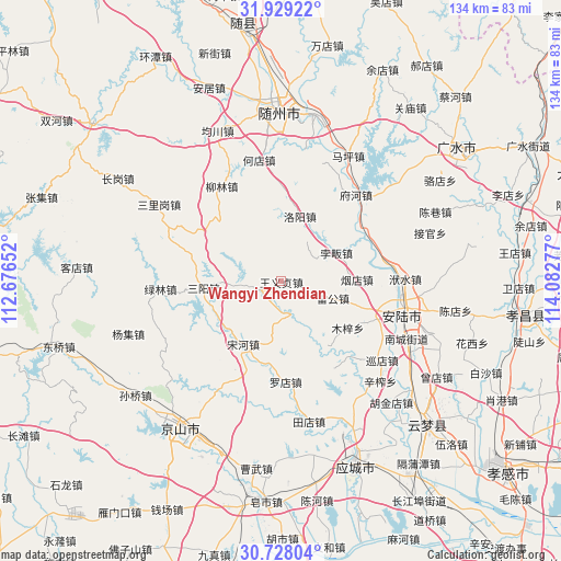
Wangyi Zhendian GPS coordinates[2]
31° 19' 49.98" North, 113° 22' 46.704" East
| Map corner | latitude | longitude |
|---|---|---|
| Upper-left | 31.92922°, | 112.67652° |
| Center: | 31.33055°, | 113.37964° |
| Lower-right: | 30.72804°, | 114.08277° |
| Map W x H: | 133.6×133.6 km | = 83×83mi |
| max Lat: | 53.31946° ⇑42.7% North |
| Wangyi Zhendian: | 31.33055° |
| min Lat: | ⇓57.3% South 18.22056° |
| min Long | Wangyi Zhendian | max Long |
| 75.07348° | 113.37964° | 134.28917° |
| W 44.9%⇐ | ⇒55.1% E |
Elevation
Elevation of Wangyi Zhendian is 96 m = 315 ft, and this is 388.8 m = 1276 ft below average elevation for this country.
| Max E: |
5622 m = 18445 ft | 60.4% |
| Avg. | 484.8 m = 1591 ft | |
| Wangyi Zhendian | 96 m = 315 ft | |
Min E: |
-3 m = -10 ft | 39.6% |
See also: China elevation on elevation.city.
Geographical zone
Wangyi Zhendian is located in North temperate zone (between Tropic of Cancer and the Arctic Circle). Distance of this Northern Tropic circle is 877.7 km =545.4 mi to South.| Distance of | km | miles | from Wangyi Zhendian |
|---|---|---|---|
| North Pole | 6523.4 | 4053.5 | to North |
| Arctic Circle | 3917.5 | 2434.2 | to North |
| Tropic Cancer | 877.7 | 545.4 | to South |
| Equator | 3483.6 | 2164.6 | to South |


Nearby cities:
15 places around Wangyi Zhendian: (largest is in red/bold)
• Beifan
14.8 km =9.2 mi,  66°
66°
• Changling
28.3 km =17.6 mi,  42°
42°
• Fuhe
26.7 km =16.6 mi, 41°
• Leigong
13.1 km =8.1 mi,  108°
108°
• Liulin
27.1 km =16.8 mi,  328°
328°
• Luodian
24.2 km =15 mi,  177°
177°
• Luoyang
16.4 km =10.2 mi,  15°
15°
• Lülin
28.8 km =17.9 mi,  266°
266°
• Muzi
19.5 km =12.1 mi,  125°
125°
• Pingba
6.2 km =3.9 mi,  254°
254°
• Pinglin
23.4 km =14.5 mi, 66°
• Sanyang
18.6 km =11.6 mi, 265°
• Songhe
17.5 km =10.9 mi,  211°
211°
• Tangdi
22.1 km =13.7 mi,  117°
117°
• Yandian
17.8 km =11.1 mi,  88°
88°
Sources, notices
• [Note1] Compared only with cities in China existing in our database
• [Src1] Map data: © OpenStreetMap contributors (CC-BY-SA)
• [Src2] Other city data from geonames.org with taken over terms of usage.
• [Src3] Geographical zone / Annual Mean Temperature by Robert A. Rohde @ Wikipedia
