Luoyang geodata
Luoyang (Hubei) is a seat of a fourth-order administrative division; located in China in Asia/Shanghai (GMT+8) time zone. In our database, there are 1268 cities with bigger population. Compared to other cities in China, 58.2% of cities are located further ↓South; 54.8% of cities are located further →East and 59.5% of cities have higher elevation than Luoyang. Note1


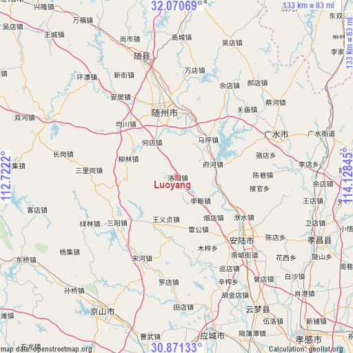
Luoyang GPS coordinates[2]
31° 28' 22.548" North, 113° 25' 31.152" East
| Map corner | latitude | longitude |
|---|---|---|
| Upper-left | 32.07069°, | 112.7222° |
| Center: | 31.47293°, | 113.42532° |
| Lower-right: | 30.87133°, | 114.12845° |
| Map W x H: | 133.4×133.4 km | = 82.9×82.9mi |
| max Lat: | 53.31946° ⇑41.8% North |
| Luoyang: | 31.47293° |
| min Lat: | ⇓58.2% South 18.22056° |
| min Long | Luoyang | max Long |
| 75.07348° | 113.42532° | 134.28917° |
| W 45.2%⇐ | ⇒54.8% E |
Elevation
Elevation of Luoyang is 101 m = 331 ft, and this is 383.8 m = 1259 ft below average elevation for this country.
| Max E: |
5622 m = 18445 ft | 59.5% |
| Avg. | 484.8 m = 1591 ft | |
| Luoyang | 101 m = 331 ft | |
Min E: |
-3 m = -10 ft | 40.5% |
See also: China elevation on elevation.city.
Geographical zone
Luoyang is located in North temperate zone (between Tropic of Cancer and the Arctic Circle). Distance of this Northern Tropic circle is 893.5 km =555.2 mi to South.| Distance of | km | miles | from Luoyang |
|---|---|---|---|
| North Pole | 6507.6 | 4043.6 | to North |
| Arctic Circle | 3901.7 | 2424.4 | to North |
| Tropic Cancer | 893.5 | 555.2 | to South |
| Equator | 3499.5 | 2174.5 | to South |


Nearby cities:
15 places around Luoyang: (largest is in red/bold)
• Beifan
13.6 km =8.5 mi,  136°
136°
• Changling
15.7 km =9.8 mi,  71°
71°
• Dayanpo
15.2 km =9.4 mi,  4°
4°
• Fuhe
14 km =8.7 mi, 73°
• Hedian
16.6 km =10.3 mi,  323°
323°
• Leigong
21.5 km =13.4 mi,  157°
157°
• Liulin
19.7 km =12.2 mi,  292°
292°
• Maping
18.5 km =11.5 mi,  39°
39°
• Nanjiao
27.7 km =17.2 mi,  344°
344°
• Pingba
20.3 km =12.6 mi,  210°
210°
• Pinglin
18.2 km =11.3 mi,  110°
110°
• Suizhou
27.1 km =16.8 mi,  347°
347°
• Wangyi Zhendian
16.4 km =10.2 mi,  195°
195°
• Xihe
24 km =14.9 mi,  9°
9°
• Yandian
20.4 km =12.7 mi, 138°
Sources, notices
• [Note1] Compared only with cities in China existing in our database
• [Src1] Map data: © OpenStreetMap contributors (CC-BY-SA)
• [Src2] Other city data from geonames.org with taken over terms of usage.
• [Src3] Geographical zone / Annual Mean Temperature by Robert A. Rohde @ Wikipedia
