Liulin geodata
Liulin (Hubei) is a seat of a fourth-order administrative division; located in China in Asia/Shanghai (GMT+8) time zone. In our database, there are 1268 cities with bigger population. Compared to other cities in China, 58.7% of cities are located further ↓South; 56.1% of cities are located further →East and 57.1% of cities have higher elevation than Liulin. Note1


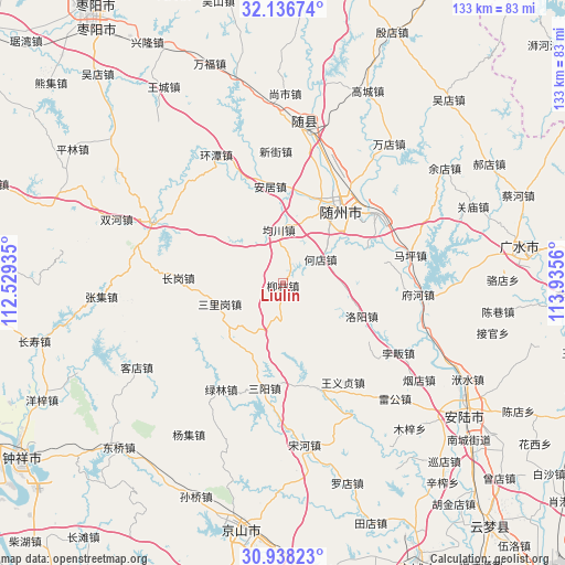
Liulin GPS coordinates[2]
31° 32' 21.876" North, 113° 13' 56.892" East
| Map corner | latitude | longitude |
|---|---|---|
| Upper-left | 32.13674°, | 112.52935° |
| Center: | 31.53941°, | 113.23247° |
| Lower-right: | 30.93823°, | 113.9356° |
| Map W x H: | 133.3×133.3 km | = 82.8×82.8mi |
| max Lat: | 53.31946° ⇑41.3% North |
| Liulin: | 31.53941° |
| min Lat: | ⇓58.7% South 18.22056° |
| min Long | Liulin | max Long |
| 75.07348° | 113.23247° | 134.28917° |
| W 43.9%⇐ | ⇒56.1% E |
Elevation
Elevation of Liulin is 117 m = 384 ft, and this is 367.8 m = 1207 ft below average elevation for this country.
| Max E: |
5622 m = 18445 ft | 57.1% |
| Avg. | 484.8 m = 1591 ft | |
| Liulin | 117 m = 384 ft | |
Min E: |
-3 m = -10 ft | 42.9% |
See also: China elevation on elevation.city.
Geographical zone
Liulin is located in North temperate zone (between Tropic of Cancer and the Arctic Circle). Distance of this Northern Tropic circle is 900.9 km =559.8 mi to South.| Distance of | km | miles | from Liulin |
|---|---|---|---|
| North Pole | 6500.2 | 4039 | to North |
| Arctic Circle | 3894.3 | 2419.8 | to North |
| Tropic Cancer | 900.9 | 559.8 | to South |
| Equator | 3506.9 | 2179.1 | to South |


Nearby cities:
15 places around Liulin: (largest is in red/bold)
• Anju
23.1 km =14.4 mi,  352°
352°
• Changgang
24.5 km =15.2 mi,  273°
273°
• Dayanpo
20.9 km =13 mi,  68°
68°
• Hedian
10.4 km =6.5 mi,  54°
54°
• Junchuan
12.6 km =7.8 mi, 353°
• Luoyang
19.7 km =12.2 mi,  112°
112°
• Lülin
29.1 km =18.1 mi,  210°
210°
• Maping
30.9 km =19.2 mi,  77°
77°
• Nanjiao
22.3 km =13.9 mi,  29°
29°
• Pingba
26.2 km =16.3 mi,  162°
162°
• Sanligang
15.9 km =9.9 mi,  251°
251°
• Sanyang
25.2 km =15.7 mi,  190°
190°
• Suizhou
22.7 km =14.1 mi, 32°
• Wangyi Zhendian
27.1 km =16.8 mi,  148°
148°
• Xihe
27.5 km =17.1 mi, 53°
Sources, notices
• [Note1] Compared only with cities in China existing in our database
• [Src1] Map data: © OpenStreetMap contributors (CC-BY-SA)
• [Src2] Other city data from geonames.org with taken over terms of usage.
• [Src3] Geographical zone / Annual Mean Temperature by Robert A. Rohde @ Wikipedia
