Shuikou geodata
Shuikou (Fujian) is a seat of a fourth-order administrative division; located in China in Asia/Shanghai (GMT+8) time zone. With population of 3,760 people, there are 907 cities with bigger population in this country. Compared to other cities in China, 80.9% of cities are located further ↑North; 74.6% of cities are located further ←West and 66.1% of cities have higher elevation than Shuikou. Note1


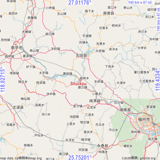
Shuikou GPS coordinates[2]
26° 23' 0.96" North, 118° 43' 48.972" East
| Map corner | latitude | longitude |
|---|---|---|
| Upper-left | 27.01176°, | 118.02715° |
| Center: | 26.3836°, | 118.73027° |
| Lower-right: | 25.75201°, | 119.4334° |
| Map W x H: | 140.1×140.1 km | = 87.1×87.1mi |
| max Lat: | 53.31946° ⇑80.9% North |
| Shuikou: | 26.3836° |
| min Lat: | ⇓19.1% South 18.22056° |
| min Long | Shuikou | max Long |
| 75.07348° | 118.73027° | 134.28917° |
| W 74.6%⇐ | ⇒25.4% E |
Elevation
Elevation of Shuikou is 68 m = 223 ft, and this is 416.8 m = 1367 ft below average elevation for this country.
| Max E: |
5622 m = 18445 ft | 66.1% |
| Avg. | 484.8 m = 1591 ft | |
| Shuikou | 68 m = 223 ft | |
Min E: |
-3 m = -10 ft | 33.9% |
See also: China elevation on elevation.city.
Geographical zone
Shuikou is located in North temperate zone (between Tropic of Cancer and the Arctic Circle). Distance of this Northern Tropic circle is 327.7 km =203.6 mi to South.| Distance of | km | miles | from Shuikou |
|---|---|---|---|
| North Pole | 7073.5 | 4395.3 | to North |
| Arctic Circle | 4467.6 | 2776 | to North |
| Tropic Cancer | 327.7 | 203.6 | to South |
| Equator | 2933.6 | 1822.9 | to South |


Nearby cities:
15 places around Shuikou: (largest is in red/bold)
• Baizhang
23.7 km =14.7 mi,  161°
161°
• Chengdong
21.7 km =13.5 mi,  2°
2°
• Dongqiao
16 km =9.9 mi,  95°
95°
• Huangtian
12.2 km =7.6 mi,  299°
299°
• Jielin
4.3 km =2.7 mi,  62°
62°
• Jinsha
22.6 km =14 mi,  185°
185°
• Meicheng
22.8 km =14.2 mi,  145°
145°
• Meipu
25.3 km =15.7 mi,  139°
139°
• Meixi
24.4 km =15.2 mi, 142°
• Panyang
21 km =13 mi,  28°
28°
• Songji
21.5 km =13.4 mi, 2°
• Xiaoruo
18.4 km =11.4 mi,  129°
129°
• Xiongjiang
5.5 km =3.4 mi,  167°
167°
• Yangli
22.5 km =14 mi, 95°
• Zhanghuban
24.5 km =15.2 mi,  270°
270°
Sources, notices
• [Note1] Compared only with cities in China existing in our database
• [Src1] Map data: © OpenStreetMap contributors (CC-BY-SA)
• [Src2] Other city data from geonames.org with taken over terms of usage.
• [Src3] Geographical zone / Annual Mean Temperature by Robert A. Rohde @ Wikipedia
