Nansha geodata
Nansha (Yunnan) is a seat of a third-order administrative division; located in China in Asia/Shanghai (GMT+8) time zone. In our database, there are 1268 cities with bigger population. Compared to other cities in China, 93.6% of cities are located further ↑North; 91.8% of cities are located further →East and 85.7% of cities have lower elevation than Nansha. Note1


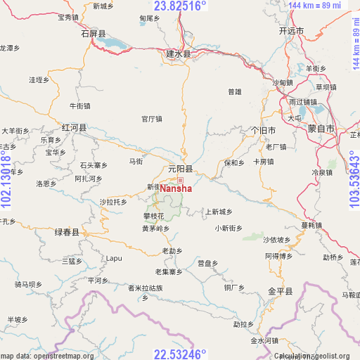
Nansha GPS coordinates[2]
23° 10' 49.332" North, 102° 49' 59.88" East
| Map corner | latitude | longitude |
|---|---|---|
| Upper-left | 23.82516°, | 102.13018° |
| Center: | 23.18037°, | 102.8333° |
| Lower-right: | 22.53246°, | 103.53643° |
| Map W x H: | 143.7×143.7 km | = 89.3×89.3mi |
| max Lat: | 53.31946° ⇑93.6% North |
| Nansha: | 23.18037° |
| min Lat: | ⇓6.4% South 18.22056° |
| min Long | Nansha | max Long |
| 75.07348° | 102.8333° | 134.28917° |
| W 8.2%⇐ | ⇒91.8% E |
Elevation
Elevation of Nansha is 1028 m = 3373 ft, and this is 543.2 m = 1782 ft above average elevation for this country.
| Max E: |
5622 m = 18445 ft | 14.3% |
| Nansha | 1028 m 3373 ft | |
| Avg. | 484.8 m = 1591 ft | |
Min E: |
-3 m = -10 ft | 85.7% |
See also: China elevation on elevation.city.
Geographical zone
Nansha is located in North Torrid zone (between Equator and Tropic of Cancer). Distance of this Northern Tropic circle is 28.5 km =17.7 mi to North.| Distance of | km | miles | from Nansha |
|---|---|---|---|
| North Pole | 7429.6 | 4616.5 | to North |
| Arctic Circle | 4823.8 | 2997.4 | to North |
| Tropic Cancer | 28.5 | 17.7 | to North |
| Equator | 2577.4 | 1601.5 | to South |


Nearby cities:
15 places around Nansha: (largest is in red/bold)
• Daxing
49.6 km =30.8 mi,  241°
241°
• Gejiu
38.4 km =23.9 mi,  58°
58°
• Huaxijie
101.2 km =62.9 mi,  10°
10°
• Jinhe
62.7 km =39 mi,  137°
137°
• Kaiyuan
74.9 km =46.5 mi,  39°
39°
• Lijiang
95.1 km =59.1 mi,  297°
297°
• Lin’an
46.9 km =29.1 mi,  359°
359°
• Lishan
99.5 km =61.8 mi, 355°
• Longwu
101.4 km =63 mi,  334°
334°
• Panjiang
97.9 km =60.8 mi,  17°
17°
• Wenlan
64.8 km =40.3 mi,  72°
72°
• Xiushan
103.6 km =64.4 mi, 355°
• Yilong
66.9 km =41.6 mi, 328°
• Yisa
42.9 km =26.7 mi,  293°
293°
• Yuping
92.6 km =57.5 mi,  104°
104°
Sources, notices
• [Note1] Compared only with cities in China existing in our database
• [Src1] Map data: © OpenStreetMap contributors (CC-BY-SA)
• [Src2] Other city data from geonames.org with taken over terms of usage.
• [Src3] Geographical zone / Annual Mean Temperature by Robert A. Rohde @ Wikipedia
