Kaiyuan geodata
Kaiyuan (Yunnan) is a populated place; located in China in Asia/Shanghai (GMT+8) time zone. With population of 198,423 people, there are 232 cities with bigger population in this country. Compared to other cities in China, 91.4% of cities are located further ↑North; 91.1% of cities are located further →East and 88.9% of cities have lower elevation than Kaiyuan. Note1


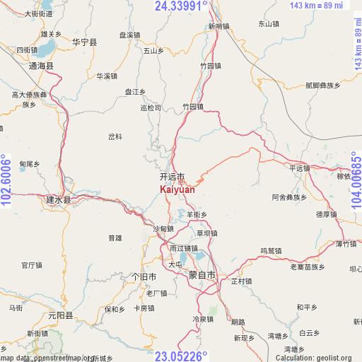
Kaiyuan GPS coordinates[2]
23° 41' 51.612" North, 103° 18' 13.392" East
| Map corner | latitude | longitude |
|---|---|---|
| Upper-left | 24.33991°, | 102.6006° |
| Center: | 23.69767°, | 103.30372° |
| Lower-right: | 23.05226°, | 104.00685° |
| Map W x H: | 143.2×143.2 km | = 89×89mi |
| max Lat: | 53.31946° ⇑91.4% North |
| Kaiyuan: | 23.69767° |
| min Lat: | ⇓8.6% South 18.22056° |
| min Long | Kaiyuan | max Long |
| 75.07348° | 103.30372° | 134.28917° |
| W 8.9%⇐ | ⇒91.1% E |
Elevation
Elevation of Kaiyuan is 1259 m = 4131 ft, and this is 774.2 m = 2540 ft above average elevation for this country.
| Max E: |
5622 m = 18445 ft | 11.1% |
| Kaiyuan | 1259 m 4131 ft | |
| Avg. | 484.8 m = 1591 ft | |
Min E: |
-3 m = -10 ft | 88.9% |
See also: Kaiyuan elevation on elevation.city.
Geographical zone
Kaiyuan is located in North temperate zone (between Tropic of Cancer and the Arctic Circle). Distance of this Northern Tropic circle is 29 km =18 mi to South.| Distance of | km | miles | from Kaiyuan |
|---|---|---|---|
| North Pole | 7372.1 | 4580.8 | to North |
| Arctic Circle | 4766.2 | 2961.6 | to North |
| Tropic Cancer | 29 | 18 | to South |
| Equator | 2634.9 | 1637.3 | to South |


Nearby cities:
15 places around Kaiyuan: (largest is in red/bold)
• Daxinshao
62.2 km =38.6 mi,  13°
13°
• Gejiu
40.5 km =25.2 mi,  202°
202°
• Hongxi
49.8 km =30.9 mi,  1°
1°
• Huaxijie
51.3 km =31.9 mi,  324°
324°
• Lin’an
49.3 km =30.6 mi,  257°
257°
• Lishan
70.1 km =43.6 mi,  306°
306°
• Nansha
74.9 km =46.5 mi,  219°
219°
• Ningzhou
67.2 km =41.8 mi, 324°
• Panjiang
40.1 km =24.9 mi,  333°
333°
• Qingnianlu
62 km =38.5 mi,  340°
340°
• Sijia
53.1 km =33 mi,  348°
348°
• Wenlan
39.9 km =24.8 mi,  160°
160°
• Xiushan
71.7 km =44.6 mi, 309°
• Yangguang
71.2 km =44.2 mi, 313°
• Zhuyuan
47.1 km =29.3 mi, 14°
Sources, notices
• [Note1] Compared only with cities in China existing in our database
• [Src1] Map data: © OpenStreetMap contributors (CC-BY-SA)
• [Src2] Other city data from geonames.org with taken over terms of usage.
• [Src3] Geographical zone / Annual Mean Temperature by Robert A. Rohde @ Wikipedia
