Gejiu geodata
Gejiu (Yunnan) is a seat of a third-order administrative division; located in China in Asia/Shanghai (GMT+8) time zone. With population of 136,135 people, there are 324 cities with bigger population in this country. Compared to other cities in China, 92.8% of cities are located further ↑North; 91.3% of cities are located further →East and 93% of cities have lower elevation than Gejiu. Note1


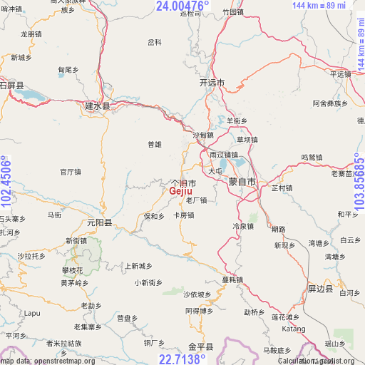
Gejiu GPS coordinates[2]
23° 21' 39.06" North, 103° 9' 13.392" East
| Map corner | latitude | longitude |
|---|---|---|
| Upper-left | 24.00476°, | 102.4506° |
| Center: | 23.36085°, | 103.15372° |
| Lower-right: | 22.7138°, | 103.85685° |
| Map W x H: | 143.5×143.5 km | = 89.2×89.2mi |
| max Lat: | 53.31946° ⇑92.8% North |
| Gejiu: | 23.36085° |
| min Lat: | ⇓7.2% South 18.22056° |
| min Long | Gejiu | max Long |
| 75.07348° | 103.15372° | 134.28917° |
| W 8.7%⇐ | ⇒91.3% E |
Elevation
Elevation of Gejiu is 1708 m = 5604 ft, and this is 1223.2 m = 4013 ft above average elevation for this country.
| Max E: |
5622 m = 18445 ft | 7% |
| Gejiu | 1708 m 5604 ft | |
| Avg. | 484.8 m = 1591 ft | |
Min E: |
-3 m = -10 ft | 93% |
See also: Gejiu elevation on elevation.city.
Geographical zone
Gejiu is located in North Torrid zone (between Equator and Tropic of Cancer). Distance of this Northern Tropic circle is 8.4 km =5.2 mi to North.| Distance of | km | miles | from Gejiu |
|---|---|---|---|
| North Pole | 7409.6 | 4604.1 | to North |
| Arctic Circle | 4803.7 | 2984.9 | to North |
| Tropic Cancer | 8.4 | 5.2 | to North |
| Equator | 2597.5 | 1614 | to South |


Nearby cities:
15 places around Gejiu: (largest is in red/bold)
• Daxing
88 km =54.7 mi,  240°
240°
• Hongxi
88.8 km =55.2 mi,  10°
10°
• Huaxijie
80.7 km =50.1 mi,  349°
349°
• Jinhe
66.8 km =41.5 mi,  171°
171°
• Kaiyuan
40.5 km =25.2 mi,  22°
22°
• Lin’an
42.5 km =26.4 mi,  309°
309°
• Lishan
89.2 km =55.4 mi,  332°
332°
• Nansha
38.4 km =23.9 mi, 238°
• Panjiang
73.3 km =45.5 mi,  357°
357°
• Sijia
89.5 km =55.6 mi,  2°
2°
• Wenlan
28.9 km =18 mi,  90°
90°
• Yilong
77.3 km =48 mi,  298°
298°
• Yisa
72.2 km =44.9 mi,  267°
267°
• Yuping
71.2 km =44.2 mi,  126°
126°
• Zhuyuan
87.3 km =54.2 mi, 17°
Sources, notices
• [Note1] Compared only with cities in China existing in our database
• [Src1] Map data: © OpenStreetMap contributors (CC-BY-SA)
• [Src2] Other city data from geonames.org with taken over terms of usage.
• [Src3] Geographical zone / Annual Mean Temperature by Robert A. Rohde @ Wikipedia
