Nanma geodata
Nanma (Shandong) is a seat of a third-order administrative division; located in China in Asia/Shanghai (GMT+8) time zone. With population of 74,406 people, there are 574 cities with bigger population in this country. Compared to other cities in China, 77.6% of cities are located further ↓South; 71.3% of cities are located further ←West and 62% of cities have lower elevation than Nanma. Note1


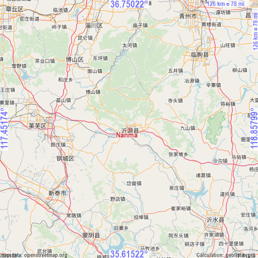
Nanma GPS coordinates[2]
36° 11' 5.208" North, 118° 9' 17.496" East
| Map corner | latitude | longitude |
|---|---|---|
| Upper-left | 36.75022°, | 117.45174° |
| Center: | 36.18478°, | 118.15486° |
| Lower-right: | 35.61522°, | 118.85799° |
| Map W x H: | 126.2×126.2 km | = 78.4×78.4mi |
| max Lat: | 53.31946° ⇑22.4% North |
| Nanma: | 36.18478° |
| min Lat: | ⇓77.6% South 18.22056° |
| min Long | Nanma | max Long |
| 75.07348° | 118.15486° | 134.28917° |
| W 71.3%⇐ | ⇒28.7% E |
Elevation
Elevation of Nanma is 283 m = 928 ft, and this is 201.8 m = 662 ft below average elevation for this country.
| Max E: |
5622 m = 18445 ft | 38% |
| Avg. | 484.8 m = 1591 ft | |
| Nanma | 283 m = 928 ft | |
Min E: |
-3 m = -10 ft | 62% |
See also: Nanma elevation on elevation.city.
Geographical zone
Nanma is located in North temperate zone (between Tropic of Cancer and the Arctic Circle). Distance of this Northern Tropic circle is 1417.5 km =880.8 mi to South.| Distance of | km | miles | from Nanma |
|---|---|---|---|
| North Pole | 5983.7 | 3718.1 | to North |
| Arctic Circle | 3377.8 | 2098.9 | to North |
| Tropic Cancer | 1417.5 | 880.8 | to South |
| Equator | 4023.4 | 2500 | to South |


Nearby cities:
15 places around Nanma: (largest is in red/bold)
• Boshan
43.9 km =27.3 mi,  319°
319°
• Dongdu
55.3 km =34.4 mi,  227°
227°
• Dongping
37.7 km =23.4 mi,  337°
337°
• Jiehu
76.3 km =47.4 mi,  159°
159°
• Laiwu
44.7 km =27.8 mi,  271°
271°
• Linqu
50.4 km =31.3 mi,  43°
43°
• Mengyin
57 km =35.4 mi,  201°
201°
• Mingshui
83.2 km =51.7 mi, 315°
• Nanding
63.3 km =39.3 mi,  351°
351°
• Qingzhou
63.9 km =39.7 mi,  27°
27°
• Xindian
69.3 km =43.1 mi,  10°
10°
• Xintai
48.1 km =29.9 mi, 228°
• Yishui
61.6 km =38.3 mi,  136°
136°
• Zhoucun
76.5 km =47.5 mi, 336°
• Zibo
67.9 km =42.2 mi, 353°
Sources, notices
• [Note1] Compared only with cities in China existing in our database
• [Src1] Map data: © OpenStreetMap contributors (CC-BY-SA)
• [Src2] Other city data from geonames.org with taken over terms of usage.
• [Src3] Geographical zone / Annual Mean Temperature by Robert A. Rohde @ Wikipedia
