Yishui geodata
Yishui (Shandong) is a populated place; located in China in Asia/Shanghai (GMT+8) time zone. With population of 94,115 people, there are 450 cities with bigger population in this country. Compared to other cities in China, 76.7% of cities are located further ↓South; 74% of cities are located further ←West and 51% of cities have higher elevation than Yishui. Note1


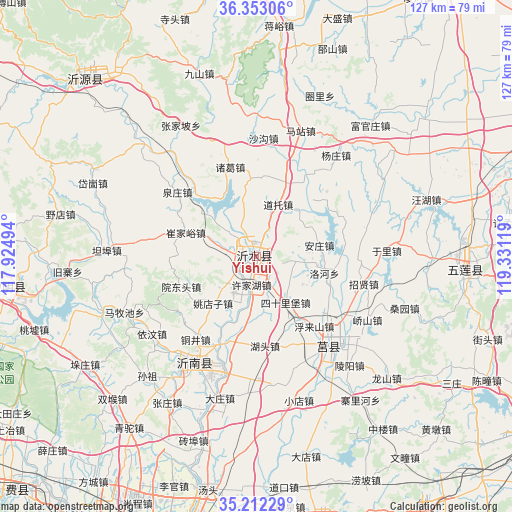
Yishui GPS coordinates[2]
35° 47' 4.992" North, 118° 37' 41.016" East
| Map corner | latitude | longitude |
|---|---|---|
| Upper-left | 36.35306°, | 117.92494° |
| Center: | 35.78472°, | 118.62806° |
| Lower-right: | 35.21229°, | 119.33119° |
| Map W x H: | 126.8×126.8 km | = 78.8×78.8mi |
| max Lat: | 53.31946° ⇑23.3% North |
| Yishui: | 35.78472° |
| min Lat: | ⇓76.7% South 18.22056° |
| min Long | Yishui | max Long |
| 75.07348° | 118.62806° | 134.28917° |
| W 74%⇐ | ⇒26% E |
Elevation
Elevation of Yishui is 156 m = 512 ft, and this is 328.8 m = 1079 ft below average elevation for this country.
| Max E: |
5622 m = 18445 ft | 51% |
| Avg. | 484.8 m = 1591 ft | |
| Yishui | 156 m = 512 ft | |
Min E: |
-3 m = -10 ft | 49% |
See also: Yishui elevation on elevation.city.
Geographical zone
Yishui is located in North temperate zone (between Tropic of Cancer and the Arctic Circle). Distance of this Northern Tropic circle is 1373 km =853.1 mi to South.| Distance of | km | miles | from Yishui |
|---|---|---|---|
| North Pole | 6028.2 | 3745.7 | to North |
| Arctic Circle | 3422.3 | 2126.5 | to North |
| Tropic Cancer | 1373 | 853.1 | to South |
| Equator | 3978.9 | 2472.4 | to South |


Nearby cities:
15 places around Yishui: (largest is in red/bold)
• Anqiu
88.2 km =54.8 mi,  35°
35°
• Chengyang
29.4 km =18.3 mi,  140°
140°
• Dongdu
84 km =52.2 mi,  274°
274°
• Feicheng
83.5 km =51.9 mi,  225°
225°
• Jiehu
31.1 km =19.3 mi,  210°
210°
• Linqu
81.6 km =50.7 mi,  354°
354°
• Linyi
84.3 km =52.4 mi,  197°
197°
• Mengyin
63.9 km =39.7 mi,  262°
262°
• Mizhou
73.1 km =45.4 mi,  71°
71°
• Nanma
61.6 km =38.3 mi,  316°
316°
• Rizhao
84.7 km =52.6 mi,  117°
117°
• Rizhao
92.5 km =57.5 mi, 117°
• Shizilu
70.6 km =43.9 mi,  165°
165°
• Xintai
80 km =49.7 mi,  279°
279°
• Zhu Cheng City
73.6 km =45.7 mi, 71°
Sources, notices
• [Note1] Compared only with cities in China existing in our database
• [Src1] Map data: © OpenStreetMap contributors (CC-BY-SA)
• [Src2] Other city data from geonames.org with taken over terms of usage.
• [Src3] Geographical zone / Annual Mean Temperature by Robert A. Rohde @ Wikipedia
