Jiehu geodata
Jiehu (Shandong) is a populated place; located in China in Asia/Shanghai (GMT+8) time zone. With population of 69,245 people, there are 617 cities with bigger population in this country. Compared to other cities in China, 76.1% of cities are located further ↓South; 72.9% of cities are located further ←West and 57.1% of cities have higher elevation than Jiehu. Note1


Jiehu GPS coordinates[2]
35° 32' 34.008" North, 118° 27' 18" East
| Map corner | latitude | longitude |
|---|---|---|
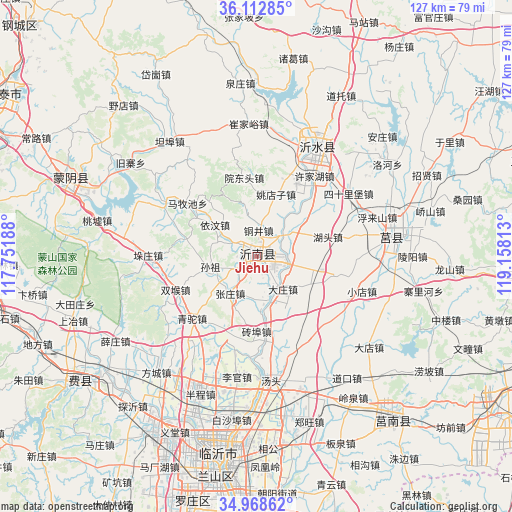
| Upper-left | 36.11285°, | 117.75188° |
| Center: | 35.54278°, | 118.455° |
| Lower-right: | 34.96862°, | 119.15813° |
| Map W x H: | 127.2×127.2 km | = 79×79mi |
| max Lat: | 53.31946° ⇑23.9% North |
| Jiehu: | 35.54278° |
| min Lat: | ⇓76.1% South 18.22056° |
| min Long | Jiehu | max Long |
| 75.07348° | 118.455° | 134.28917° |
| W 72.9%⇐ | ⇒27.1% E |
Elevation
Elevation of Jiehu is 117 m = 384 ft, and this is 367.8 m = 1207 ft below average elevation for this country.
| Max E: |
5622 m = 18445 ft | 57.1% |
| Avg. | 484.8 m = 1591 ft | |
| Jiehu | 117 m = 384 ft | |
Min E: |
-3 m = -10 ft | 42.9% |
See also: Jiehu elevation on elevation.city.
Geographical zone
Jiehu is located in North temperate zone (between Tropic of Cancer and the Arctic Circle). Distance of this Northern Tropic circle is 1346.1 km =836.4 mi to South.| Distance of | km | miles | from Jiehu |
|---|---|---|---|
| North Pole | 6055.1 | 3762.5 | to North |
| Arctic Circle | 3449.2 | 2143.2 | to North |
| Tropic Cancer | 1346.1 | 836.4 | to South |
| Equator | 3952 | 2455.7 | to South |


Nearby cities:
15 places around Jiehu: (largest is in red/bold)
• Andongwei
87.5 km =54.4 mi,  121°
121°
• Bianzhuang
85.7 km =53.3 mi,  205°
205°
• Chengyang
34.4 km =21.4 mi,  83°
83°
• Dongdu
76.3 km =47.4 mi,  296°
296°
• Feicheng
54.2 km =33.7 mi,  234°
234°
• Haitou
93.8 km =58.3 mi,  136°
136°
• Linyi
54.3 km =33.7 mi,  190°
190°
• Mengyin
51.1 km =31.8 mi,  290°
290°
• Nanma
76.3 km =47.4 mi,  339°
339°
• Pingyi
74.7 km =46.4 mi,  266°
266°
• Rizhao
91.5 km =56.9 mi,  98°
98°
• Shizilu
53.5 km =33.2 mi, 140°
• Xiazhuang
71.7 km =44.6 mi,  166°
166°
• Xintai
74.9 km =46.5 mi, 302°
• Yishui
31.1 km =19.3 mi,  30°
30°
Sources, notices
• [Note1] Compared only with cities in China existing in our database
• [Src1] Map data: © OpenStreetMap contributors (CC-BY-SA)
• [Src2] Other city data from geonames.org with taken over terms of usage.
• [Src3] Geographical zone / Annual Mean Temperature by Robert A. Rohde @ Wikipedia
