Songyang geodata
Songyang (Henan) is a seat of a third-order administrative division; located in China in Asia/Shanghai (GMT+8) time zone. With population of 62,375 people, there are 690 cities with bigger population in this country. Compared to other cities in China, 72.5% of cities are located further ↓South; 57.5% of cities are located further →East and 68.1% of cities have lower elevation than Songyang. Note1


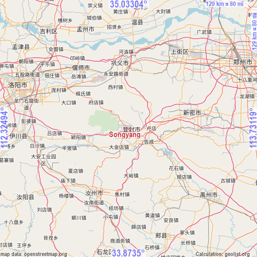
Songyang GPS coordinates[2]
34° 27' 19.008" North, 113° 1' 41.016" East
| Map corner | latitude | longitude |
|---|---|---|
| Upper-left | 35.03304°, | 112.32494° |
| Center: | 34.45528°, | 113.02806° |
| Lower-right: | 33.8735°, | 113.73119° |
| Map W x H: | 128.9×128.9 km | = 80.1×80.1mi |
| max Lat: | 53.31946° ⇑27.5% North |
| Songyang: | 34.45528° |
| min Lat: | ⇓72.5% South 18.22056° |
| min Long | Songyang | max Long |
| 75.07348° | 113.02806° | 134.28917° |
| W 42.5%⇐ | ⇒57.5% E |
Elevation
Elevation of Songyang is 379 m = 1243 ft, and this is 105.8 m = 347 ft below average elevation for this country.
| Max E: |
5622 m = 18445 ft | 31.9% |
| Avg. | 484.8 m = 1591 ft | |
| Songyang | 379 m = 1243 ft | |
Min E: |
-3 m = -10 ft | 68.1% |
See also: Songyang elevation on elevation.city.
Geographical zone
Songyang is located in North temperate zone (between Tropic of Cancer and the Arctic Circle). Distance of this Northern Tropic circle is 1225.1 km =761.2 mi to South.| Distance of | km | miles | from Songyang |
|---|---|---|---|
| North Pole | 6176 | 3837.6 | to North |
| Arctic Circle | 3570.1 | 2218.4 | to North |
| Tropic Cancer | 1225.1 | 761.2 | to South |
| Equator | 3831.1 | 2380.5 | to South |


Nearby cities:
15 places around Songyang: (largest is in red/bold)
• Anliang
50.5 km =31.4 mi,  154°
154°
• Ciba
41.9 km =26 mi,  176°
176°
• Guangkuotiandi
55.8 km =34.7 mi,  166°
166°
• Huangdao
44.7 km =27.8 mi,  164°
164°
• Huichang
54.6 km =33.9 mi,  335°
335°
• Jiyuanlu
46.3 km =28.8 mi,  28°
28°
• Qianying
54 km =33.6 mi,  191°
191°
• Qingping
33.1 km =20.6 mi,  74°
74°
• Ruzhou
37.4 km =23.2 mi,  209°
209°
• Suohe
47.7 km =29.6 mi,  39°
39°
• Wenquan
53.5 km =33.2 mi,  4°
4°
• Xuedian
49.6 km =30.8 mi, 173°
• Yanshi Chengguanzhen
36 km =22.4 mi,  323°
323°
• Yingchuan
51.6 km =32.1 mi,  129°
129°
• Zijinglu
34.3 km =21.3 mi,  351°
351°
Sources, notices
• [Note1] Compared only with cities in China existing in our database
• [Src1] Map data: © OpenStreetMap contributors (CC-BY-SA)
• [Src2] Other city data from geonames.org with taken over terms of usage.
• [Src3] Geographical zone / Annual Mean Temperature by Robert A. Rohde @ Wikipedia
