Micheng geodata
Micheng (Yunnan) is a seat of a third-order administrative division; located in China in Asia/Shanghai (GMT+8) time zone. In our database, there are 1268 cities with bigger population. Compared to other cities in China, 85% of cities are located further ↑North; 94.1% of cities are located further →East and 92.7% of cities have lower elevation than Micheng. Note1


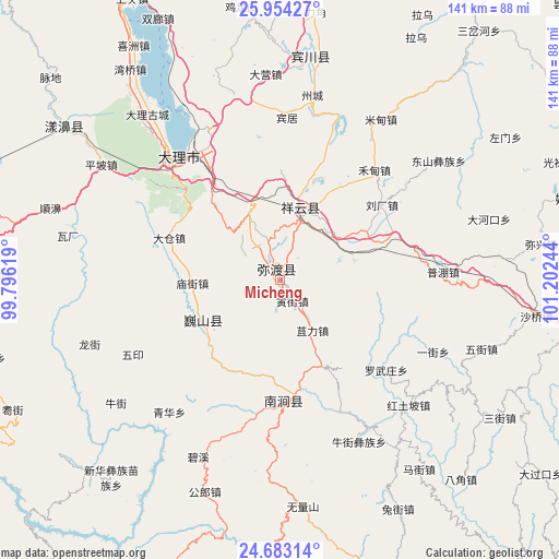
Micheng GPS coordinates[2]
25° 19' 13.332" North, 100° 29' 57.516" East
| Map corner | latitude | longitude |
|---|---|---|
| Upper-left | 25.95427°, | 99.79619° |
| Center: | 25.32037°, | 100.49931° |
| Lower-right: | 24.68314°, | 101.20244° |
| Map W x H: | 141.3×141.3 km | = 87.8×87.8mi |
| max Lat: | 53.31946° ⇑85% North |
| Micheng: | 25.32037° |
| min Lat: | ⇓15% South 18.22056° |
| min Long | Micheng | max Long |
| 75.07348° | 100.49931° | 134.28917° |
| W 5.9%⇐ | ⇒94.1% E |
Elevation
Elevation of Micheng is 1662 m = 5453 ft, and this is 1177.2 m = 3862 ft above average elevation for this country.
| Max E: |
5622 m = 18445 ft | 7.3% |
| Micheng | 1662 m 5453 ft | |
| Avg. | 484.8 m = 1591 ft | |
Min E: |
-3 m = -10 ft | 92.7% |
See also: China elevation on elevation.city.
Geographical zone
Micheng is located in North temperate zone (between Tropic of Cancer and the Arctic Circle). Distance of this Northern Tropic circle is 209.4 km =130.1 mi to South.| Distance of | km | miles | from Micheng |
|---|---|---|---|
| North Pole | 7191.7 | 4468.7 | to North |
| Arctic Circle | 4585.8 | 2849.5 | to North |
| Tropic Cancer | 209.4 | 130.1 | to South |
| Equator | 2815.4 | 1749.4 | to South |


Nearby cities:
15 places around Micheng: (largest is in red/bold)
• Dali
41.2 km =25.6 mi,  315°
315°
• Dongchuan
80.8 km =50.2 mi,  77°
77°
• Fengshan
101.8 km =63.3 mi,  216°
216°
• Gonghe
102.7 km =63.8 mi,  94°
94°
• Jinbi
94.5 km =58.7 mi,  62°
62°
• Jinniu
53.9 km =33.5 mi,  8°
8°
• Jinping
103.8 km =64.5 mi,  161°
161°
• Laojie
95.8 km =59.5 mi,  278°
278°
• Longchuan
81.9 km =50.9 mi,  102°
102°
• Nanjian
30.5 km =19 mi,  173°
173°
• Nanzhao
22.5 km =14 mi,  241°
241°
• Shangjie
65.1 km =40.5 mi,  306°
306°
• Xiangcheng
17.5 km =10.9 mi,  21°
21°
• Youdian
106.4 km =66.1 mi, 239°
• Yuhu
101.6 km =63.1 mi,  329°
329°
Sources, notices
• [Note1] Compared only with cities in China existing in our database
• [Src1] Map data: © OpenStreetMap contributors (CC-BY-SA)
• [Src2] Other city data from geonames.org with taken over terms of usage.
• [Src3] Geographical zone / Annual Mean Temperature by Robert A. Rohde @ Wikipedia
