Youdian geodata
Youdian (Yunnan) is a seat of a third-order administrative division; located in China in Asia/Shanghai (GMT+8) time zone. In our database, there are 1268 cities with bigger population. Compared to other cities in China, 87.1% of cities are located further ↑North; 94.8% of cities are located further →East and 93.8% of cities have lower elevation than Youdian. Note1


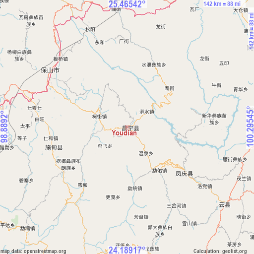
Youdian GPS coordinates[2]
24° 49' 44.184" North, 99° 35' 32.352" East
| Map corner | latitude | longitude |
|---|---|---|
| Upper-left | 25.46542°, | 98.8892° |
| Center: | 24.82894°, | 99.59232° |
| Lower-right: | 24.18917°, | 100.29545° |
| Map W x H: | 141.9×141.9 km | = 88.2×88.2mi |
| max Lat: | 53.31946° ⇑87.1% North |
| Youdian: | 24.82894° |
| min Lat: | ⇓12.9% South 18.22056° |
| min Long | Youdian | max Long |
| 75.07348° | 99.59232° | 134.28917° |
| W 5.2%⇐ | ⇒94.8% E |
Elevation
Elevation of Youdian is 1822 m = 5978 ft, and this is 1337.2 m = 4387 ft above average elevation for this country.
| Max E: |
5622 m = 18445 ft | 6.2% |
| Youdian | 1822 m 5978 ft | |
| Avg. | 484.8 m = 1591 ft | |
Min E: |
-3 m = -10 ft | 93.8% |
See also: China elevation on elevation.city.
Geographical zone
Youdian is located in North temperate zone (between Tropic of Cancer and the Arctic Circle). Distance of this Northern Tropic circle is 154.8 km =96.2 mi to South.| Distance of | km | miles | from Youdian |
|---|---|---|---|
| North Pole | 7246.3 | 4502.6 | to North |
| Arctic Circle | 4640.5 | 2883.5 | to North |
| Tropic Cancer | 154.8 | 96.2 | to South |
| Equator | 2760.7 | 1715.4 | to South |


Nearby cities:
15 places around Youdian: (largest is in red/bold)
• Aihua
68.8 km =42.8 mi,  131°
131°
• Dali
104.7 km =65.1 mi,  36°
36°
• Dedang
97.6 km =60.6 mi,  201°
201°
• Dianyang
45.9 km =28.5 mi,  252°
252°
• Fengshan
41.4 km =25.7 mi, 131°
• Jinping
131.6 km =81.8 mi,  109°
109°
• Laojie
69 km =42.9 mi,  356°
356°
• Longshan
93.2 km =57.9 mi, 254°
• Micheng
106.4 km =66.1 mi,  59°
59°
• Nanjian
97.8 km =60.8 mi,  75°
75°
• Nanzhao
83.9 km =52.1 mi, 58°
• Shangjie
101.4 km =63 mi,  22°
22°
• Shimen
119.6 km =74.3 mi,  352°
352°
• Tengyue
110.4 km =68.6 mi,  279°
279°
• Xiangcheng
120.7 km =75 mi,  54°
54°
Sources, notices
• [Note1] Compared only with cities in China existing in our database
• [Src1] Map data: © OpenStreetMap contributors (CC-BY-SA)
• [Src2] Other city data from geonames.org with taken over terms of usage.
• [Src3] Geographical zone / Annual Mean Temperature by Robert A. Rohde @ Wikipedia
