Laojie geodata
Laojie (Yunnan) is a seat of a third-order administrative division; located in China in Asia/Shanghai (GMT+8) time zone. In our database, there are 1268 cities with bigger population. Compared to other cities in China, 84.5% of cities are located further ↑North; 94.8% of cities are located further →East and 93.7% of cities have lower elevation than Laojie. Note1


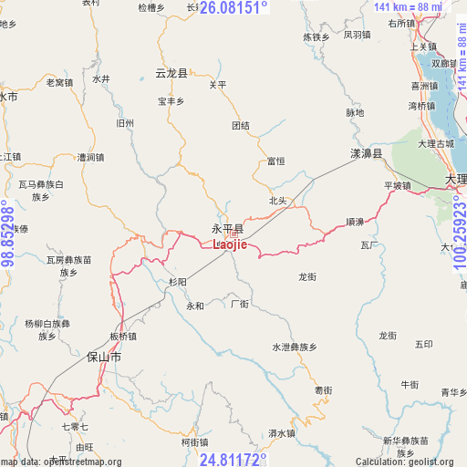
Laojie GPS coordinates[2]
25° 26' 53.844" North, 99° 33' 21.96" East
| Map corner | latitude | longitude |
|---|---|---|
| Upper-left | 26.08151°, | 98.85298° |
| Center: | 25.44829°, | 99.5561° |
| Lower-right: | 24.81172°, | 100.25923° |
| Map W x H: | 141.2×141.2 km | = 87.7×87.7mi |
| max Lat: | 53.31946° ⇑84.5% North |
| Laojie: | 25.44829° |
| min Lat: | ⇓15.5% South 18.22056° |
| min Long | Laojie | max Long |
| 75.07348° | 99.5561° | 134.28917° |
| W 5.2%⇐ | ⇒94.8% E |
Elevation
Elevation of Laojie is 1811 m = 5942 ft, and this is 1326.2 m = 4351 ft above average elevation for this country.
| Max E: |
5622 m = 18445 ft | 6.3% |
| Laojie | 1811 m 5942 ft | |
| Avg. | 484.8 m = 1591 ft | |
Min E: |
-3 m = -10 ft | 93.7% |
See also: China elevation on elevation.city.
Geographical zone
Laojie is located in North temperate zone (between Tropic of Cancer and the Arctic Circle). Distance of this Northern Tropic circle is 223.7 km =139 mi to South.| Distance of | km | miles | from Laojie |
|---|---|---|---|
| North Pole | 7177.5 | 4459.9 | to North |
| Arctic Circle | 4571.6 | 2840.7 | to North |
| Tropic Cancer | 223.7 | 139 | to South |
| Equator | 2829.6 | 1758.2 | to South |


Nearby cities:
15 places around Laojie: (largest is in red/bold)
• Dali
67.6 km =42 mi,  77°
77°
• Dianyang
92 km =57.2 mi,  205°
205°
• Fengshan
102.2 km =63.5 mi,  160°
160°
• Jinding
110.8 km =68.8 mi,  354°
354°
• Jinniu
109.3 km =67.9 mi,  69°
69°
• Luzhang
93.8 km =58.3 mi,  308°
308°
• Micheng
95.8 km =59.5 mi,  98°
98°
• Nanjian
107.8 km =67 mi,  114°
114°
• Nanzhao
79.2 km =49.2 mi, 108°
• Shangjie
49.2 km =30.6 mi,  59°
59°
• Shimen
51.2 km =31.8 mi, 345°
• Tengyue
116.4 km =72.3 mi,  244°
244°
• Xiangcheng
101.1 km =62.8 mi,  88°
88°
• Youdian
69 km =42.9 mi,  176°
176°
• Yuhu
84.8 km =52.7 mi,  30°
30°
In other languages:
- In Chinese: Chiu-ch’eng, Yung-p’ing-hsien, Ch’ü-tung, Ch’ü-t’ung-chieh, Yung-p’ing, 老街
Sources, notices
• [Note1] Compared only with cities in China existing in our database
• [Src1] Map data: © OpenStreetMap contributors (CC-BY-SA)
• [Src2] Other city data from geonames.org with taken over terms of usage.
• [Src3] Geographical zone / Annual Mean Temperature by Robert A. Rohde @ Wikipedia
