Fengshan geodata
Fengshan (Yunnan) is a seat of a third-order administrative division; located in China in Asia/Shanghai (GMT+8) time zone. In our database, there are 1268 cities with bigger population. Compared to other cities in China, 88.2% of cities are located further ↑North; 94.6% of cities are located further →East and 93.1% of cities have lower elevation than Fengshan. Note1


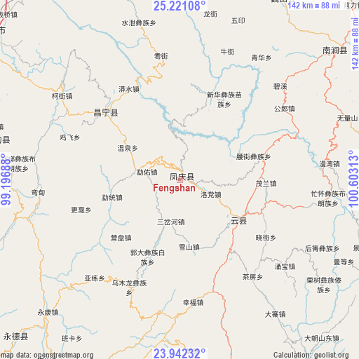
Fengshan GPS coordinates[2]
24° 34' 59.988" North, 99° 54' 0" East
| Map corner | latitude | longitude |
|---|---|---|
| Upper-left | 25.22108°, | 99.19688° |
| Center: | 24.58333°, | 99.9° |
| Lower-right: | 23.94232°, | 100.60313° |
| Map W x H: | 142.2×142.2 km | = 88.4×88.4mi |
| max Lat: | 53.31946° ⇑88.2% North |
| Fengshan: | 24.58333° |
| min Lat: | ⇓11.8% South 18.22056° |
| min Long | Fengshan | max Long |
| 75.07348° | 99.9° | 134.28917° |
| W 5.4%⇐ | ⇒94.6% E |
Elevation
Elevation of Fengshan is 1727 m = 5666 ft, and this is 1242.2 m = 4075 ft above average elevation for this country.
| Max E: |
5622 m = 18445 ft | 6.9% |
| Fengshan | 1727 m 5666 ft | |
| Avg. | 484.8 m = 1591 ft | |
Min E: |
-3 m = -10 ft | 93.1% |
See also: China elevation on elevation.city.
Geographical zone
Fengshan is located in North temperate zone (between Tropic of Cancer and the Arctic Circle). Distance of this Northern Tropic circle is 127.5 km =79.2 mi to South.| Distance of | km | miles | from Fengshan |
|---|---|---|---|
| North Pole | 7273.7 | 4519.7 | to North |
| Arctic Circle | 4667.8 | 2900.4 | to North |
| Tropic Cancer | 127.5 | 79.2 | to South |
| Equator | 2733.4 | 1698.5 | to South |


Nearby cities:
15 places around Fengshan: (largest is in red/bold)
• Aihua
27.4 km =17 mi,  132°
132°
• Dali
115.7 km =71.9 mi,  15°
15°
• Dedang
92.3 km =57.4 mi,  226°
226°
• Dianyang
76 km =47.2 mi,  280°
280°
• Gengma
129.2 km =80.3 mi,  204°
204°
• Jinping
94.5 km =58.7 mi,  100°
100°
• Laojie
102.2 km =63.5 mi,  340°
340°
• Longshan
120.9 km =75.1 mi,  270°
270°
• Mengmeng
124.7 km =77.5 mi,  184°
184°
• Micheng
101.8 km =63.3 mi,  36°
36°
• Nanjian
82.1 km =51 mi,  51°
51°
• Nanzhao
81.9 km =50.9 mi,  29°
29°
• Shangjie
121.2 km =75.3 mi,  3°
3°
• Xiangcheng
118.8 km =73.8 mi, 34°
• Youdian
41.4 km =25.7 mi,  311°
311°
Sources, notices
• [Note1] Compared only with cities in China existing in our database
• [Src1] Map data: © OpenStreetMap contributors (CC-BY-SA)
• [Src2] Other city data from geonames.org with taken over terms of usage.
• [Src3] Geographical zone / Annual Mean Temperature by Robert A. Rohde @ Wikipedia
