Jinping geodata
Jinping (Yunnan) is a seat of a third-order administrative division; located in China in Asia/Shanghai (GMT+8) time zone. In our database, there are 1268 cities with bigger population. Compared to other cities in China, 88.7% of cities are located further ↑North; 93.9% of cities are located further →East and 91.6% of cities have lower elevation than Jinping. Note1


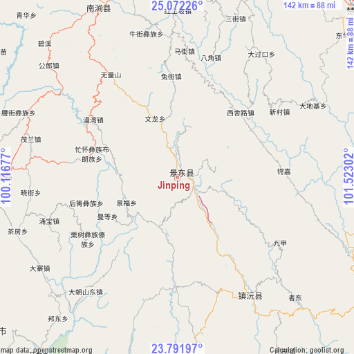
Jinping GPS coordinates[2]
24° 26' 1.464" North, 100° 49' 11.604" East
| Map corner | latitude | longitude |
|---|---|---|
| Upper-left | 25.07226°, | 100.11677° |
| Center: | 24.43374°, | 100.81989° |
| Lower-right: | 23.79197°, | 101.52302° |
| Map W x H: | 142.4×142.4 km | = 88.5×88.5mi |
| max Lat: | 53.31946° ⇑88.7% North |
| Jinping: | 24.43374° |
| min Lat: | ⇓11.3% South 18.22056° |
| min Long | Jinping | max Long |
| 75.07348° | 100.81989° | 134.28917° |
| W 6.1%⇐ | ⇒93.9% E |
Elevation
Elevation of Jinping is 1530 m = 5020 ft, and this is 1045.2 m = 3429 ft above average elevation for this country.
| Max E: |
5622 m = 18445 ft | 8.4% |
| Jinping | 1530 m 5020 ft | |
| Avg. | 484.8 m = 1591 ft | |
Min E: |
-3 m = -10 ft | 91.6% |
See also: China elevation on elevation.city.
Geographical zone
Jinping is located in North temperate zone (between Tropic of Cancer and the Arctic Circle). Distance of this Northern Tropic circle is 110.9 km =68.9 mi to South.| Distance of | km | miles | from Jinping |
|---|---|---|---|
| North Pole | 7290.3 | 4530 | to North |
| Arctic Circle | 4684.4 | 2910.8 | to North |
| Tropic Cancer | 110.9 | 68.9 | to South |
| Equator | 2716.8 | 1688.1 | to South |


Nearby cities:
15 places around Jinping: (largest is in red/bold)
• Aihua
72.9 km =45.3 mi,  268°
268°
• Dongchuan
125.1 km =77.7 mi,  22°
22°
• Enle
59 km =36.7 mi,  153°
153°
• Fengshan
94.5 km =58.7 mi,  280°
280°
• Fuliangpengjie
129.2 km =80.3 mi,  95°
95°
• Gonghe
115.4 km =71.7 mi,  37°
37°
• Guishan
127 km =78.9 mi,  109°
109°
• Longchuan
94 km =58.4 mi,  30°
30°
• Micheng
103.8 km =64.5 mi,  341°
341°
• Nanjian
74.2 km =46.1 mi, 336°
• Nanzhao
102 km =63.4 mi,  329°
329°
• Tongchang
126.7 km =78.7 mi,  75°
75°
• Tuodian
86.2 km =53.6 mi,  72°
72°
• Weiyuan
108.2 km =67.2 mi,  187°
187°
• Xiangcheng
117.8 km =73.2 mi,  347°
347°
Sources, notices
• [Note1] Compared only with cities in China existing in our database
• [Src1] Map data: © OpenStreetMap contributors (CC-BY-SA)
• [Src2] Other city data from geonames.org with taken over terms of usage.
• [Src3] Geographical zone / Annual Mean Temperature by Robert A. Rohde @ Wikipedia
