Xinhuang geodata
Xinhuang (Hunan) is a seat of a third-order administrative division; located in China in Asia/Shanghai (GMT+8) time zone. In our database, there are 1268 cities with bigger population. Compared to other cities in China, 77.1% of cities are located further ↑North; 75.7% of cities are located further →East and 70.3% of cities have lower elevation than Xinhuang. Note1


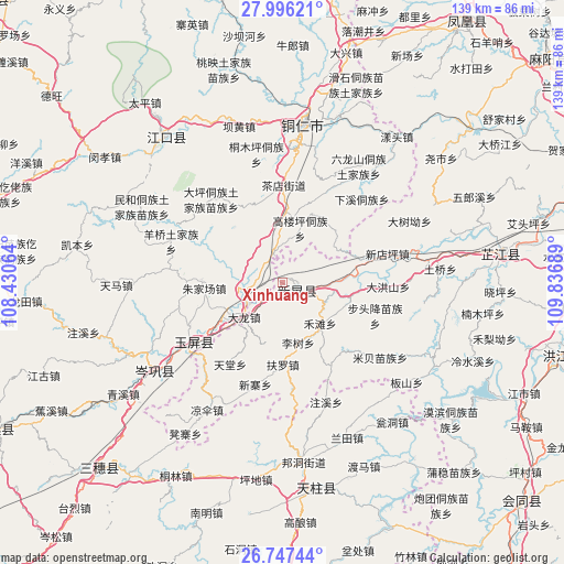
Xinhuang GPS coordinates[2]
27° 22' 24.924" North, 109° 8' 1.536" East
| Map corner | latitude | longitude |
|---|---|---|
| Upper-left | 27.99621°, | 108.43064° |
| Center: | 27.37359°, | 109.13376° |
| Lower-right: | 26.74744°, | 109.83689° |
| Map W x H: | 138.9×138.9 km | = 86.3×86.3mi |
| max Lat: | 53.31946° ⇑77.1% North |
| Xinhuang: | 27.37359° |
| min Lat: | ⇓22.9% South 18.22056° |
| min Long | Xinhuang | max Long |
| 75.07348° | 109.13376° | 134.28917° |
| W 24.3%⇐ | ⇒75.7% E |
Elevation
Elevation of Xinhuang is 417 m = 1368 ft, and this is 67.8 m = 222 ft below average elevation for this country.
| Max E: |
5622 m = 18445 ft | 29.7% |
| Avg. | 484.8 m = 1591 ft | |
| Xinhuang | 417 m = 1368 ft | |
Min E: |
-3 m = -10 ft | 70.3% |
See also: China elevation on elevation.city.
Geographical zone
Xinhuang is located in North temperate zone (between Tropic of Cancer and the Arctic Circle). Distance of this Northern Tropic circle is 437.7 km =272 mi to South.| Distance of | km | miles | from Xinhuang |
|---|---|---|---|
| North Pole | 6963.4 | 4326.9 | to North |
| Arctic Circle | 4357.5 | 2707.6 | to North |
| Tropic Cancer | 437.7 | 272 | to South |
| Equator | 3043.7 | 1891.3 | to South |


Nearby cities:
15 places around Xinhuang: (largest is in red/bold)
• Bahuang
39.9 km =24.8 mi,  343°
343°
• Bozhou
14.2 km =8.8 mi,  87°
87°
• Chadian
23.2 km =14.4 mi,  359°
359°
• Gongxi
29.1 km =18.1 mi,  174°
174°
• Liangsan
35.7 km =22.2 mi,  208°
208°
• Mibei
30.4 km =18.9 mi,  127°
127°
• Minhe
39.9 km =24.8 mi,  297°
297°
• Mulong
40 km =24.9 mi,  350°
350°
• Tongren
38.5 km =23.9 mi,  7°
7°
• Wanshan
18.1 km =11.2 mi,  23°
23°
• Yangliugou
34.9 km =21.7 mi,  286°
286°
• Yangping
41.4 km =25.7 mi,  233°
233°
• Youyupu
19.8 km =12.3 mi,  0°
0°
• Zhongzhai
23.9 km =14.9 mi,  146°
146°
• Zhujiachang
19.4 km =12.1 mi,  264°
264°
Sources, notices
• [Note1] Compared only with cities in China existing in our database
• [Src1] Map data: © OpenStreetMap contributors (CC-BY-SA)
• [Src2] Other city data from geonames.org with taken over terms of usage.
• [Src3] Geographical zone / Annual Mean Temperature by Robert A. Rohde @ Wikipedia
