Bozhou geodata
Bozhou (Hunan) is a populated place; located in China in Asia/Shanghai (GMT+8) time zone. With population of 1,150 people, there are 1145 cities with bigger population in this country. Compared to other cities in China, 77.1% of cities are located further ↑North; 75% of cities are located further →East and 64.2% of cities have lower elevation than Bozhou. Note1


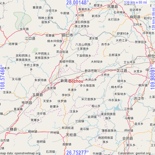
Bozhou GPS coordinates[2]
27° 22' 44.004" North, 109° 16' 40.008" East
| Map corner | latitude | longitude |
|---|---|---|
| Upper-left | 28.00148°, | 108.57466° |
| Center: | 27.37889°, | 109.27778° |
| Lower-right: | 26.75277°, | 109.98091° |
| Map W x H: | 138.8×138.8 km | = 86.2×86.2mi |
| max Lat: | 53.31946° ⇑77.1% North |
| Bozhou: | 27.37889° |
| min Lat: | ⇓22.9% South 18.22056° |
| min Long | Bozhou | max Long |
| 75.07348° | 109.27778° | 134.28917° |
| W 25%⇐ | ⇒75% E |
Elevation
Elevation of Bozhou is 313 m = 1027 ft, and this is 171.8 m = 564 ft below average elevation for this country.
| Max E: |
5622 m = 18445 ft | 35.8% |
| Avg. | 484.8 m = 1591 ft | |
| Bozhou | 313 m = 1027 ft | |
Min E: |
-3 m = -10 ft | 64.2% |
See also: China elevation on elevation.city.
Geographical zone
Bozhou is located in North temperate zone (between Tropic of Cancer and the Arctic Circle). Distance of this Northern Tropic circle is 438.3 km =272.3 mi to South.| Distance of | km | miles | from Bozhou |
|---|---|---|---|
| North Pole | 6962.8 | 4326.5 | to North |
| Arctic Circle | 4356.9 | 2707.3 | to North |
| Tropic Cancer | 438.3 | 272.3 | to South |
| Equator | 3044.2 | 1891.6 | to South |


Nearby cities:
15 places around Bozhou: (largest is in red/bold)
• Biyong
31.3 km =19.4 mi,  132°
132°
• Chadian
26.7 km =16.6 mi,  327°
327°
• Gongxi
31.7 km =19.7 mi,  201°
201°
• Lantian
39.4 km =24.5 mi,  177°
177°
• Mibei
21.5 km =13.4 mi,  152°
152°
• Nanmuping
40.3 km =25 mi,  100°
100°
• Tongren
38.7 km =24 mi,  346°
346°
• Wanshan
17.5 km =10.9 mi,  336°
336°
• Xinhuang
14.2 km =8.8 mi,  267°
267°
• Yangtou
37 km =23 mi,  21°
21°
• Yaoshi
38.2 km =23.7 mi,  40°
40°
• Youyupu
23.8 km =14.8 mi,  323°
323°
• Zhijiang
38.7 km =24 mi,  76°
76°
• Zhongzhai
20.4 km =12.7 mi, 182°
• Zhujiachang
33.6 km =20.9 mi, 265°
Sources, notices
• [Note1] Compared only with cities in China existing in our database
• [Src1] Map data: © OpenStreetMap contributors (CC-BY-SA)
• [Src2] Other city data from geonames.org with taken over terms of usage.
• [Src3] Geographical zone / Annual Mean Temperature by Robert A. Rohde @ Wikipedia
