Wen’an geodata
Wen’an (Hubei) is a seat of a fourth-order administrative division; located in China in Asia/Shanghai (GMT+8) time zone. In our database, there are 1268 cities with bigger population. Compared to other cities in China, 50.5% of cities are located further ↓South; 63.4% of cities are located further →East and 69.5% of cities have higher elevation than Wen’an. Note1


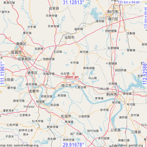
Wen’an GPS coordinates[2]
30° 31' 27.624" North, 111° 49' 21.828" East
| Map corner | latitude | longitude |
|---|---|---|
| Upper-left | 31.12813°, | 111.11961° |
| Center: | 30.52434°, | 111.82273° |
| Lower-right: | 29.91678°, | 112.52586° |
| Map W x H: | 134.7×134.7 km | = 83.7×83.7mi |
| max Lat: | 53.31946° ⇑49.5% North |
| Wen’an: | 30.52434° |
| min Lat: | ⇓50.5% South 18.22056° |
| min Long | Wen’an | max Long |
| 75.07348° | 111.82273° | 134.28917° |
| W 36.6%⇐ | ⇒63.4% E |
Elevation
Elevation of Wen’an is 54 m = 177 ft, and this is 430.8 m = 1413 ft below average elevation for this country.
| Max E: |
5622 m = 18445 ft | 69.5% |
| Avg. | 484.8 m = 1591 ft | |
| Wen’an | 54 m = 177 ft | |
Min E: |
-3 m = -10 ft | 30.5% |
See also: China elevation on elevation.city.
Geographical zone
Wen’an is located in North temperate zone (between Tropic of Cancer and the Arctic Circle). Distance of this Northern Tropic circle is 788.1 km =489.7 mi to South.| Distance of | km | miles | from Wen’an |
|---|---|---|---|
| North Pole | 6613.1 | 4109.2 | to North |
| Arctic Circle | 4007.2 | 2490 | to North |
| Tropic Cancer | 788.1 | 489.7 | to South |
| Equator | 3394 | 2108.9 | to South |


Nearby cities:
15 places around Wen’an: (largest is in red/bold)
• Anfusi
22.7 km =14.1 mi,  270°
270°
• Bailizhou
13.4 km =8.3 mi,  189°
189°
• Baiyang
32.1 km =19.9 mi,  249°
249°
• Banyue
10.3 km =6.4 mi,  2°
2°
• Chuandian
25.1 km =15.6 mi,  72°
72°
• Dongshi
17.2 km =10.7 mi,  221°
221°
• Gujiadian
31.9 km =19.8 mi,  227°
227°
• Herong
24.9 km =15.5 mi,  35°
35°
• Laocheng
22.7 km =14.1 mi,  208°
208°
• Lianghe
22.1 km =13.7 mi,  25°
25°
• Qixingtai
13.8 km =8.6 mi,  153°
153°
• Wangdian
25.2 km =15.7 mi,  324°
324°
• Xiannü
7.9 km =4.9 mi, 272°
• Yaqueling
26.3 km =16.3 mi,  300°
300°
• Zhijiang
13.2 km =8.2 mi, 210°
Sources, notices
• [Note1] Compared only with cities in China existing in our database
• [Src1] Map data: © OpenStreetMap contributors (CC-BY-SA)
• [Src2] Other city data from geonames.org with taken over terms of usage.
• [Src3] Geographical zone / Annual Mean Temperature by Robert A. Rohde @ Wikipedia
